Landscape Architect Bob Grese
Fascinated by Ann Arbor's vanished prairies, he recreated one in his own front yard
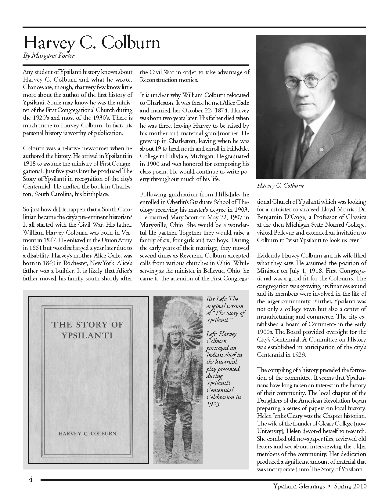
When Bob Grese turned the front lawn of his house on Ann Arbor's west side into a prairie, his neighbors didn't know what to make of it. They had been very happy the year before to learn that a landscape architect had bought the run-down property, an eyesore on the street. And they had since become fond of the mild-mannered, smiling Grese, who brought delicious natural foods to their neighborhood potlucks. But they had expected something a little different from his landscaping efforts than five-foot-tall grasses.
Grese (pronounced GRAY-see), thirty seven, is an associate professor in the U-M School of Natural Resources and chair of the landscape architecture program. He started his prairie three years ago as a teaching tool. His small house, built in the 1920's, probably as a garage, is set back on its lot, dwarfed by a long front yard. Grese planted the area nearest the house as a woodland opening, with wildflowers. The middle section is prairie, with five kinds of grasses and an assortment of prairie flowers (black-eyed Susan and other cone Cowers, bee balm, ironweed), tapering off again into a woodland opening near the street. He put trees at the front to give it a more landscaped look, and planted the front edge of the yard with natural ground covers—wild strawberry, dewberry, and Virginia creeper.
In growing his prairie, Grese is going one step further back than his Old West Side neighbors who work to restore their houses to their original appearance. He is reconstructing a landscape that existed before Ann Arbor was settled. Looking at old survey maps, he has identified a prairie that was here when John Alien and Elisha Rumsey platted the town in 1824. It began where Slauson school is, just a few blocks from Grese's house on Charlton.
Grese started his prairie by burning (with city permission) the vegetation already in his yard. Burning suppresses European lawn grasses and woody plants and puts nutrients back in the soil to help the native plants thrive. Whenever possible, Grese likes to begin his prairie projects by burning. He never has any problem getting volunteers to help. "Burning holds a real enchantment for people," he says. "There's a primal attraction to fire."
Dark-haired and slight (though muscular, probably from biking and hiking), Grese knows his own attraction to prairies is not widely shared. "It's easier for most people to appreciate forests rather than prairies," he says. As part of a small but growing movement of prairie restorers, Grese wants to change this. He has helped schoolkids set up prairies at Thurston Nature Center and Leslie Science Center with "stomping parties," where the children themselves sow the seeds of wild grasses and flowers. He has led workshops on prairies and is active in several state and national environmental organizations.
Grese especially enjoys leading field trips to remnants of prairies past. There were once prairies and oak savannas (woodland openings) throughout this area. Alien and Rumsey reportedly picked Ann Arbor as a town site because of the oak openings along the Huron River. The southeastern part of the city was a wet prairie (which explains why basements in that area often flood). Grese has found many prairie remnants around town: along the railroad tracks between Dexter and Ann Arbor; behind the Catherine McAuley campus on Huron River Drive (called the Shanghai prairie because turn-of-the-century Chinese workers mined gravel there); on drain commission land between US-23 and Platt Road; Dow Field in the Nichols Arboretum; and in parts of Barton and Gallup parks.
Grese's serious interest in prairies began when he was in graduate school at the University of Wisconsin in the 1980's, where he studied and helped with an experimental prairie. But his interest in plants and nature goes back to his grade-school years, when his family lived on two and a half acres in Chattanooga, Tennessee. Neither his parents (his father was a Lutheran minister) nor his ten siblings were particularly interested in nature, but Grese loved the wooded area around his childhood home, where the grass grew wild. "I was enchanted with the place,'' he says.
At Washington University in St.Louis in 1973, Grese began studying architecture, but decided he was more interested in the grounds around the buildings than in the buildings themselves. He switched to landscape architecture and transferred to the University of Georgia, where he received his B.A. Once he began working, the job he liked best was recording the route of the trail along Pennsylvania's Lehigh Canal for the Historic America Engineering Record. Bored with-the everyday mechanics of landscape architecture and wanting to learn more about plants, he returned to graduate school at the University of Wisconsin, where he earned a master's in 1984. He taught two years at the University of Virginia before coming to the U-M, where he won tenure earlier this year.
Besides his interest in prairies, Grese has pursued two other specialties: children's nature education and the history of landscape architecture. The period of landscape history that Grese has focused on is, appropriately enough, the prairie landscape movement, a counterpart to Frank Lloyd Wright's prairie architecture. He's an admirer of Jens Jensen, a leader of the movement, which encouraged the use of native plants in landscape design. Grese's book, Jens Jensen: Maker of National Parks and Gardens, was recently published by Johns Hopkins University Press.
Grese is a softspoken individual with strong convictions about local issues that touch on the environment. He thinks conservation efforts such as protection of wetlands or Ann Arbor's recently proposed natural features ordinance are steps in the right direction, but he emphasizes, "We need to protect [the environment] as a larger continuum. It makes no sense to protect wetlands and then pave right up to them, to not protect the upland."
As for the natural features ordinance, Grese worries that it could go too far and indiscriminately protect everything—including "weed trees" that he thinks should be cut down to make room for the restoration of native species. (Debate on just what the ordinance will cover is continuing.)
He would like to see the city's forestry department concentrate on planting trees indigenous to this area (white and bur oaks, chestnuts) instead of imports like zelkova trees. Although the zelkovas are meant to replace the city's vanished American elms, Grese complains that "they don't have the grace or charm" of the native species.
Grese's vocation is also his avocation. Although he likes folk music, he finds he's too busy working in his gardens (he has two besides the prairie) to go to many concerts. Part of him seems nostalgic for a slower-paced American past. After an inner struggle, he decided to give up his car, a 1980 Datsun. One day last February, he drove it to Town and Country auto recyclers on Wagner and bicycled back home.
Grese's own prairie is sometimes a shock to people who see it for the first time, bursting up above the neatly mowed lawns along the street. Former neighbor Mary Jo Gord says that when she and her husband were selling their house on Charlton recently, many prospective buyers mistook Grese's residence for an overgrown and abandoned house.
But over time, his neighbors have become accustomed to the prairie. Although no one has followed his example and begun their own, they enjoy the offerings of his—increased butterfly populations in the summer, more birds in the winter, the grasses turning various colors in the fall, and the snow making changing patterns in the winter.

Building the County Parks
How a political gambit led the way
It is hard to imagine now just how rare parks were in Washtenaw County in 1972. Ann Arbor and other big towns had their own parks, and there were the Metroparks on the river and the state recreation areas at the northwest edge of the county. But the county’s only parks were a few rest areas run by the Washtenaw County Road Commission. Former road commission employee Carl Thayer remembers there wasn’t much to them—just “hand-mowed areas right beside the road with a picnic table and a green trash barrel.”
Things began to change in 1972, when Meri Lou Murray ran for county commissioner—by default. As Third Ward chair for the Ann Arbor Democratic Party, Murray was responsible for finding a candidate for her county board district. But since that district was then considered a Republican stronghold, no Democrat wanted to run. The party told Murray she would have to fill the slot herself.
Figuring they had nothing to lose, she and her campaign committee decided to think big—and came up with the idea of advocating for a county park system.
Murray won in an upset victory that fall and went on to shepherd into existence a county parks department that now has twenty-seven facilities on about 3,400 acres. The county system has thirty-three full-time employees, more than 300 seasonal jobs, and an annual budget that ranges from $6 million to $8 million depending on whether the system is buying land that year. And it’s long since expanded from rural parks to include active-recreation facilities and protected natural areas.
The Washtenaw County Parks and Recreation Commission held its first meeting in August 1973. Initially, all it oversaw was four roadside parks inherited from the road commission. But things began to pick up the following August, when WCPARC hired its first director, Bob Gamble.
Parks commissioner Nelson Meade recalls that the search had come down to two finalists, but one took a job in a bigger community, and the other hesitated to come to a county with no park millage to fund its system. Then, toward the end of the process, Gamble applied.
After reading his resume, which included being director of parks in Nassau County, Long Island, Meade wrote Gamble to say, “You’re out of our league. We can’t afford you.” But Gamble explained that his needs were modest and that he had lost the Nassau County job when the people who hired him were voted out of office. Although employed elsewhere, he was anxious to get back into park work. Meade recalls that at an interview in the county planning department’s conference room, “Bob lolled in his chair, but he charmed us. We hired him instantly.”
The commission still had virtually no budget, but one of the roadside parks, Park Lyndon, was surrounded by 205 undeveloped acres that the state had given to the county in 1960. Gamble got a federal grant to build a parking lot, a picnic pavilion, toilets, and a small cabin, and he recruited federally funded job training employees to lay out trails. Park Lyndon is now one of the jewels of the park system—“one of the premier nature preserves east of the Mississippi,” according to current county parks head Bob Tetens.
Murray recalls that the commissioners themselves helped set up fitness trails, using equipment made by the job trainees in a hangar at the city airport. At the County Service Center at Washtenaw and Hogback, formerly a Roman Catholic seminary, they commandeered the old gym for exercise classes, ignoring the noise from the sheriff’s shooting range in the basement.
Parks commissioner Bob Marans, a U-M professor of architecture and urban planning, arranged for students to survey county residents on their priorities for the new park system. Preserving open space came out on top, followed by a swimming beach and a park in the eastern part of the county. Gamble recommended creating parks at Independence Lake in Webster Township and on a property south of Ypsilanti with a small pond—today’s Rolling Hills County Park.
In August 1976 the county asked voters for a quarter-mill, ten-year park tax. Gamble stayed up all night after the election waiting for the votes to come in. When the final tally was announced, the proposal was 349 votes short of approval. “Bob was devastated,” recalls Nelson Meade. But the very next night the parks commissioners asked the board of commissioners to put the millage back on the fall ballot. They were worried that if they waited two years until the next countywide election, the land would be lost to private developers.
The night of the fall 1976 election, Gamble was so confident he went to bed at his normal time. He awoke the next morning to find that the millage had passed by 5,000 votes. Environmentally minded voters may have turned out in especially large numbers that year because the state’s returnable-bottle law proposal was on the ballot—but the county parks never again lost a millage campaign.
With a steady source of revenue, WCPARC won federal matching grants to buy and develop Independence Lake and Rolling Hills. Murray herself securied another key parcel when, after years of lobbying, she convinced her fellow county commissioners to donate the former county poor farm on Washtenaw to the park system. It’s now County Farm Park.
Bob Gamble retired in 1980. His successor, Roger Shedlock, oversaw the opening of Rolling Hills in 1983, and the historic Parker Mill on Geddes the following year.
The original ten-year millage was due to run out in 1986, but the parks commissioners decided to put the renewal on the ballot in 1984. They were pleasantly surprised when it easily passed on the first try.
In 1985, Shedlock was succeeded by Fred Barkley, a former county and regional planner. In July 1988, Barkley went to a convention in Portland, Oregon, to receive an award for Parker Mill’s trail system. “One day, while walking by the Portland City Hall,” Barkley recalls, “I saw kids playing in water shooting up in a spray.” He decided to add “interactive sprays” at both Independence Lake and Rolling Hills. At Rolling Hills, Barkley also replaced the original swimming pond with an elaborate water park complete with a water slide and a wave pool. According to Barkley, it was Michigan’s first public water park.
By then, most of the original millage was being spent to maintain the existing parks. The commissioners realized that if they wanted to continue to buy land, they would need another millage, and in 1988 voters approved a second quarter mill. Renewals of both the original and new millages easily passed in 1994 and 1998. The county uses one for operations and the other for park acquisitions and major improvements.
An indoor recreation center opened at County Farm Park in 1990. Built in the shape of a barn to honor the site’s history, it includes a swimming pool, a gym, exercise equipment, a walking area, and space for fitness classes. When Meri Lou Murray retired from the county commission in 1996, it was renamed in her honor. The Meri Lou Murray Recreation Center is now the most-used facility in the entire county park system.
Barkley’s last big projects were the golf course on Pierce Lake near Chelsea, more improvements at Rolling Hills and Independence Lake, and the purchase of Sharon Mills County Park near Manchester. Most of these were finished by his successor, Bob Tetens, who took over in 2001. Like Barkley, Tetens is a former planner who exudes enthusiasm for the parks. He seems to carry a mental map of the county in his head: whenever a potential park site is mentioned, he knows its physical properties and whether it is for sale or might be in the future.
Built in the 1830s on the Raisin River, Sharon Mills had been a Ford parts plant, a home, an antique store, and a winery before WCPARC bought it. The county restored the mill building and added handicapped-accessible restrooms, a pergola, terraces, and a pavilion. Plans call for adding walking and mountain bike trails on 119 recently purchased acres across the road.
In 2001 voters approved a new quarter-mill tax to preserve natural areas. At the time the county had just one nature preserve; now there are fourteen, all of them accessible to the public. “People can’t appreciate or understand nature unless they can experience it,” says Tetens.
The other big project since Tetens arrived has been the effort to complete a
border-to-border nonmotorized trail throughout the county. Also called “linear parks,” such trails open large stretches of land to the public. But they also require close collaboration with units of governments, individual landowners, and other park systems. “Some [obstacles] are difficult, some are expensive, but none are insurmountable,” says Tetens. He predicts that when it’s finished, the B2B trail will garner national recognition.
This year the county parks are thirty-five years old. With its second millage up for renewal, WCPARC has again developed a master plan describing what it will do with the money. For instance, since research shows a need for more sports facilities, the commissioners are working on an expansion plan for Rolling Hills that would include more space for disc golf and soccer and a “miracle field” with a rubberized surface that is safer for handicapped children and seniors. Similar improvements are being planned for the other parks. Also on the drawing boards is another indoor recreation center.
Tetens is very excited about the system’s future. “More than any other land use, parks have the ability to transcend time,” he says. “I am confident that the parks and preserves developed today will still be serving the Washtenaw County citizens a hundred years in the future. Parks are forever."
Location is Everything
Mills, roads, and trains shaped Washtenaw’s towns
In 1824 thirty-eight-year-old Orange Risdon and thirty-two-year-old Samuel Dexter spent four months on horseback exploring mostly uninhabited land in southeast Michigan. At the end of the 2,000-mile trip, they settled within a few miles of each other.
Risdon bought 160 acres fronting the Great Sauk Trail, the Indian footpath that ran all the way from Detroit to Rock Island, Illinois. Dexter bought land that included a stream that flowed into the Huron River, ideal for powering mills and machines and for irrigating. These were the beginnings of Saline and Dexter.
Risdon and Dexter came from very different backgrounds. Risdon left school when he was thirteen and was always proud he’d earned his own way. He learned surveying by apprenticing in western New York, where he helped lay out the towns of Lockport, Brockport, and Buffalo. During the War of 1812 he served as an assistant surveyor for the army. In 1816 he married Sally Newland. Six of their children were born in upstate New York, and the seventh and last in Saline.
Dexter’s ancestors, members of the Protestant ruling class in Ireland, came to the United States in 1642, fleeing a rebellion. His father, Samuel Dexter VI, was a Massachusetts congressman and senator who also served in the cabinets of two presidents. He was secretary of war under John Adams and secretary of the treasury under Adams and Thomas Jefferson.
Samuel Dexter VII obtained both a college degree and a law degree at Harvard--unusual at a time when most lawyers learned by apprenticeship. When he finished law school in 1815, he set up a practice in Athens, New York. The next year he married a local woman, Amelia Augusta Prevost, and they started a family.
In 1822 Amelia and their two-year-old son both died. Dexter decided he needed to start a new life rather than obsess over his losses. He later wrote to a cousin, “I came to Michigan to get rid of the blue devils, or to speak more politely of the ennui which like a demon pursues those who have nothing to do.”
Michigan Territory was established in 1805, but most of the land remained in the hands of Native tribes until 1819, when they ceded much of the Lower Peninsula in the Treaty of Saginaw. The following year the government started reselling the land to settlers for $1.25 an acre. The first permanent settlement in Washtenaw County, Woodruff’s Grove, was founded in 1823 (today it’s part of Ypsilanti).
It’s not known how or where Risdon and Dexter met or why they ended up exploring together. But Risdon, too, had suffered misfortune in New York--he had been speculating in land, and lost money in the panic of 1817. Michigan needed surveying, so Risdon came here in 1823 and spent a month exploring on foot. The following year he and Dexter found new centers for their lives.
Dexter built a sawmill on the stream that ran through his property, naming it Mill Creek, and went back to New York that winter. Risdon found work extending Woodward Avenue from Detroit to Pontiac. He also started work on a map of Michigan lands available for settlement.
In 1825 Risdon became the chief surveyor for the first major road built across the state. Father Gabriel Richard, Michigan Territory’s representative in Congress, had convinced the federal government to build a wagon road along the Sauk Trail. Though sold to Congress as a way to move troops quickly in case of an Indian uprising, it proved more useful in settling the state. Known variously as the Military Road, Chicago Road, or Old Sauk Trial, today it is US-12 or Michigan Avenue.
The survey was difficult. Risdon wrote to his wife, Sally, of “job delays” and “the hardship of the weather and other obstructions,” noting that after “a few days wading in warm water our feet were so sore it was like dipping them in scalding water. We had to stop every three or four days to doctor.”
Meanwhile Dexter returned to Michigan with a new bride, Susan Dunham. They lived first in a log house on the west side of Mill Creek--originally built for the mill workers, it was the first residence in Webster Township. Then he built a wooden house near the Huron River on what is now Huron Street. On the other side of Mill Creek, Dexter had a gristmill built.
When Dexter and Risdon first came to Michigan, the trip overland was long and tedious, made worse by a swampy area near Toledo. In 1824 it took Ann Allen, the wife of Ann Arbor cofounder John Allen, two months to make her way from Virginia in a covered wagon. But in 1825 the Erie Canal opened, shortening trips from the East considerably. From the canal’s terminus at Buffalo, travelers could board a steamboat and get to Detroit in three days.
By 1826 enough settlers were coming that the organization of Washtenaw County, carved out of Wayne County in 1822, could begin. Territorial governor Lewis Cass appointed Samuel Dexter its first chief justice. He was also the village postmaster; once a week he rode to Ann Arbor to hear cases and get the town’s mail.
Dexter continued to develop his village. He built and stocked a drugstore in order to lure the area’s first doctor, Cyril Nichols. He donated land for several churches. He had the first school built. And he started Forest Lawn Cemetery after Susan died in childbirth, followed soon by their infant son.
A year later Dexter married sixteen-year-old Millicent Bond, who had come to Webster Township the year before with her mother and sisters. A justice of the peace presided at Millicent’s sister’s house. The bride and groom rode horses back to the village. “Millicent’s trousseau was packed in the saddle bags that Dexter used to carry the mail,” wrote their granddaughter Ione Stannard in a family remembrance. “When fording the Huron River her wedding dress was dampened but the saddle bags kept the judge’s trousers dry.”
Both Dexter and John Allen were fervent anti-Masons, part of a short-lived movement whose members believed Masonic lodges were conspiring to take over the country. Annoyed that Washtenaw County’s only newspaper was neutral on the issue, the two men bought the Western Emigrant in 1829. Allen, perennially short of money, soon sold his share of the paper to Dexter. From then on Judge Dexter’s trips to Ann Arbor included working on the paper. “Once a week my father rode to Ann Arbor on his fine white horse, with saddle bags strapped to the saddle behind him, to edit and print his paper,” his daughter Julia Stannard recalled in 1895. If Dexter planned to stay overnight in Ann Arbor, Millicent, who had been appointed his assistant postmaster, rode with him so she could bring back the mail the same day. According to family legend, one night she was followed home by a panther that stalked her until she reached the village.
In 1829 Orange Risdon finally stopped returning to New York each winter and moved his family to Saline. He and Sally built a house on a hill near the Saline River overlooking the Chicago Road. The house served as a stagecoach stop and inn. It also was the town’s post office for the ten years that Risdon was postmaster, and a courtroom and wedding chapel for the twelve years he was justice of the peace. Voters in the first Saline Township election cast their ballots in the house in April 1830. For good measure, the front parlor was rented to Silas Finch to use as a general store. Like Dexter, Risdon donated land for schools, churches, and a cemetery.
Both Dexter and Risdon waited a few years to plat their new villages--Dexter was busy developing his mills and Risdon was surveying. In 1830, when Dexter finally got around to laying out his town, he was helped by twenty-year-old John Doane. “We began the survey at the west end of Main and Ann Arbor streets, the judge picking out the trees to mark for the center of the street, which now comprises the business part of Dexter,” Doane later wrote. “After the stakes were glazed, I had his instructions to pace three rods each side of the stake to form Ann Arbor Street.” Risdon laid out Saline two years later, no doubt using more professional methods.
In the early nineteenth century, water and roads determined the locations of towns. By the middle of the century, railroads played a big role too. Manchester began in 1832 with the damming of the River Raisin. Chelsea was established in 1850 when Elisha and James Congdon convinced the Michigan Central to locate a railroad station on their farm.
Unlike Dexter and Saline, Manchester did not have the advantage of a single strong leader. But within the current village limits, the River Raisin dropped forty feet, offering great prospects for powering mills. Settlement began in 1832 when John Gilbert, an Ypsilanti entrepreneur, bought twenty-two acres straddling the river. Gilbert hired Emanuel Case to dam the river and then build and run a gristmill and a sawmill.
The following year James Soule put another dam a mile downstream and built a bridge and a sawmill, starting a separate settlement known as Soulesville and later as East Manchester. A third dam was built between the first two, at what is now the Furnace Street bridge. Barnabas Case built a distillery there in 1838 and Amos Dickinson a foundry a year later. These early dams were primitive affairs “built by laying trees and logs lengthwise of the stream and throwing on stones and dirt to the required height,” according to Manchester’s First Hundred Years.
Emanuel Case built the town’s first hotel, a block east of his mills. He kept an office there in his role as justice of the peace. The hotel was rebuilt in 1869 as the Goodyear House, later known as Freeman’s. Today it’s a gas station, but the hotel dining room’s tin ceiling can still be seen in the back room.
The mills drew more settlers to Manchester. In 1834 Lewis Allen built the first school, William Carr opened the first store, and Dr. Bennett Root started the first medical practice. The block east of the mill filled with shops.
After Risdon completed work on the Old Sauk Trail, a new road was built north of it to bring settlers into the second tier of counties north of Ohio. (Originally called the Territorial Road, it’s now known variously as Jackson Road or Old US-12.) Around the same time, a north-south wagon road, today’s M-52, connected Manchester to Stockbridge.
In 1832 brothers Nathan and Darius Pierce came to Washtenaw County from upstate New York. The house Nathan built on the Territorial Road still stands on the north side of Old US-12, just east of the entrance to Chelsea Community Hospital. Nathan often put up travelers overnight--and when one visitor didn’t get up the next morning, Pierce started the cemetery on Old Manchester Road near the fairgrounds.
Other settlers soon arrived in “Pierceville.” Stephen Winans kept a store, postmaster Albert Holt ran a sash and blind factory, and Israel Bailey was the blacksmith.
Darius Pierce settled north of his brother, where the Manchester road crossed Letts Creek. About five families gathered there and christened the hamlet Kedron. Farther south, at the corner of today’s Jerusalem Road, was a settlement called Vermont Colony. With no waterpower, these communities could not develop into manufacturing centers, but they did serve as trading towns for the surrounding farms.
In 1833 brothers Elisha and James Congdon arrived from Chelsea Landing, Connecticut. Elisha bought 160 acres south of Kedron on the east side of the Manchester road. James purchased 300 acres across the road. This proved to be an ideal location.
In 1841 Samuel Dexter donated land to enable the Michigan Central Railroad to reach his town. The next stopping point west was a small refueling station on Hugh Davidson’s farm, just west of James Congdon’s spread. When the station burned down in 1848, the Congdons gave the railroad land for a new station where the tracks crossed the Manchester road. Their donation made it easier for farmers to bring their crops to the train, and businesspeople from Pierceville began moving closer to the depot so they, too, could more easily send and get goods. The residents of Vermont Colony also relocated nearer the station, building a Congregational church on land donated by the Congdons. And so Chelsea was established.
The railroads let farmers ship their goods much farther and faster. As they prospered, so did the towns that served them--Dexter and Chelsea grew quickly because of the Michigan Central. In 1855 the Michigan Southern built a spur that passed through Manchester, followed in 1870 by a Detroit, Hillsdale, and Indiana line that passed through both Saline and Manchester. Orange Risdon was at the festivities marking the train’s arrival in his town; he died in 1876 at age eighty-nine.
All four communities have preserved landmarks to celebrate and honor their early years. Chelsea’s railroad station is now a museum and meeting place, and Elisha Congdon’s house is part of the beautifully expanded McKune Memorial Library. Dexter’s historic landmarks include its railroad station and Gordon Hall, Samuel Dexter’s third residence.
Manchester tore down its railroad station but saved its last blacksmith shop as a museum. The last Manchester Mill is now divided into offices and shops. In Saline, Orange Risdon’s house was moved to 210 West Henry Street in 1949 to make room for Oakwood Cemetery; it’s still there, now divided into apartments. Saline’s old depot is a historical museum, and on its grounds is Risdon’s livery barn. A walking path follows the old train tracks.
The Dexter Underpass
Commuters cursing delays at the narrow railroad underpass on the west end of Dexter should direct their anger at Charles Warner’s cow.
The bridge over Dexter-Pinckney Road was designed in 1890 by Frederick Blackburn Pelham, the first African American to graduate from the University of Michigan in engineering. But it might never have been built if Warner’s cow hadn’t calved on Sunday morning, March 20, 1887.
When Warner didn’t show up for church, his parents, Dennis and Martha Warner, became concerned. That afternoon they walked from their house in the village toward Charles’s farm, which he had taken over from them years before. As they began to cross the tracks, the Michigan Central’s Limited Express roared around the curve at forty-five miles per hour. Dennis Warner made it across, but his wife did not. “Mrs. Warner evidently became slightly confused, hesitated an instant, and just as she stepped from the track was struck by the pilot [cowcatcher] of the locomotive, throwing her head against the cylinder, crushing her skull and killing her instantly,” reported the Dexter Leader.
To be going so fast, the train must not have stopped at the train station at Third and Broad, rebuilt just a year earlier. But an inquest determined the railroad was not at fault. The Michigan Central, which ran from Detroit to Chicago, had been rolling through Dexter since 1841.
The Warners were early Dexter settlers. In 1837, when the crops failed on his farm, Dennis Warner came into town and found work shoveling gravel on the embankment being built for the railroad. He also started making shoes, and parlayed that into a general mercantile business. At the time of his wife’s death, he owned a whole block of stores on the south side of Main Street.
The accident cast a “pall of gloom over the entire community,” reported the Leader. After the funeral, held at the Congregational church on Fifth Street, townsfolk began petitioning the railroad to build a bridge at the crossing. At the time the Michigan Central was making improvements all along the line, and the railroad assigned Pelham, a young civil engineer whose specialty was bridge building, to design new bridges over the road and over Mill Creek. Both elegant stone structures are still there, the latter behind the fire station at the end of Warrior Park.
Pelham began working for the Michigan Central as an assistant engineer the year Martha Warner died, shortly after his graduation from the U-M. Born in 1865, he had grown up in Detroit, the youngest of seven children of Robert and Frances Pelham, who had moved from Virginia. Robert Pelham was a stonemason, and his son often worked with him on projects around Detroit.
Frederick Pelham excelled in math. According to The Michigan Manual of Freedmen’s Progress, published in 1915, he graduated at the top of his U-M class. The Dexter underpass was the most unusual of the twenty bridges that Pelham designed in Michigan because of its skew arch, a design used when bridges are not perpendicular to crossings. Before putting in the stone arch, the workers dug under the rail bed and put in a temporary wooden frame. They used the soil they removed to raise the banks of Mill Creek and straighten it out, filling in an old millrace so that the creek wouldn’t harm the new bridge.
Stone bridges were the best available at the time for durability, strength, and easy maintenance, but only wealthier railroads could afford them. “The enormous amounts of labor needed--especially the skilled labor of stonemasons--made this type of bridge costly,” explains Charles Hyde, author of Historic Highway Bridges of Michigan.
For the Dexter bridges the masons collected stones from Mill Creek and sized them by hand. One of the stonemasons was Peter McGinn. “He worked on viaducts in Ireland; he knew how to cut stone,” said his granddaughter, Alice Vencil, in an interview in October, a month before she died. According to Vencil, her grandfather came to Michigan to work with the railroad on bridges all around the state.
Neither McGinn nor Pelham has his name among those engraved under the bridge; the persons so honored are higher officials--H. B. Ledyard, the Michigan Central president, and L. D. Hawks, the railroad’s head engineer.
After graduating from the U-M, Pelham returned to Detroit to live with his parents. He did some work on the interurban system there, taught Sunday school at Detroit’s Bethel AME Church, and was a member of the Michigan Engineering Society and the YMCA. Pelham died at age thirty in 1895.
Longtime Dexter residents recall that it used to be common for engineering students from the U-M to make field trips to study Pelham’s bridge and its skew arch. For decades, the underpass was fine for pedestrians and horse-drawn buggies, and later for automobiles. But as the area’s population has grown and traffic has increased, it has become more of a bottleneck, especially during rush hours.
Officials are considering two possible solutions: building a bypass from Parker Road to Dexter-Pinckney Road west of Gordon Hall, or building a new underpass just to the south and retaining the current one for pedestrians and bicycles. But altering Pelham’s masterpiece isn’t on the table.
415 West Washington
The garage at the center of the greenway debate
When the Washtenaw County Road Commission built a garage at 415 West Washington in 1925, no one dreamed that its future would ever be so hotly contested. But today, the Arts Alliance of the Ann Arbor Area, Downtown Kiwanis, and the Allen Creek Task Force have all taken an interest in the crumbling masonry structure.
When the WCRC began operating in 1919, its offices were in the County Courthouse, and the site on West Washington was a storage yard. By 1921, when former U-M All-American football player Ernie Allmendinger began working there, the commission maintained 104 miles of roads, only 8 miles of which were paved.
By 1925 it could afford its own building—a simple concrete structure with offices above a garage. Three years later, the commission added a one-story workshop, and in 1930 the complex took on its present form with the completion of an additional, brick garage.
By 1937 the WCRC staff was maintaining 1,411 miles of road. In an article written ten years later, Allmendinger recalled how three-person crews would go out and determine road and fence lines, often with the help of property owners who showed them markers or deeds. The commission would then make improvements, such as straightening roads, extending culverts, reshaping steep hills, and digging drainage ditches.
During the Great Depression, there was never enough time or money to do all that was needed. Then, in World War II, it was impossible to buy new equipment, or even parts for old equipment.
"We didn't have tools. We would work by hand, by shovel," recalls Thomas Kittel, who worked at the road commission after graduating from high school in 1944, and then again when he came back from the war in 1946.
In spring the challenge was to make muddy roads passable, mainly by spreading gravel. Then the crews had to grade the dirt roads to smooth out the ruts and potholes. If they didn't finish the road surfaces fast enough, "they would dry up harder than the devil," remembered one worker.
In the summer the challenge was the reverse—keeping them from becoming too dusty. Washtenaw was the first county in the state to use liquid chloride to solve this problem. John Rayburn and Ernie Schellenberger worked on the first chloride truck. Rayburn recalls that he opened the tap that let out the chloride while Schellenberger drove.
Winter was the most challenging time. The crews would mix sand with flaky, solid chloride to keep the sand from freezing. During snowstorms, Carl Thayer's job was to stand at the back of the truck and push the sand onto a wheel that spread it onto the road. When Thayer got too cold, he would bang with his shovel on the back of the cab, and the driver would stop and let him come in to warm up.
WCRC employees fortunate enough to have indoor or part-indoor jobs—surveying, engineering, bookkeeping, purchasing, and personnel—worked on the second floor of the main building. Two other small county offices were also there: planning, with two full-time employees, and building inspections, with one. Eileen Westfall Gondak worked half time in each.
Gondak, who started as a teenager in 1948, recalls that her boss, planner George Hurrell, "worried about the strip [on Washtenaw] between Ypsilanti and Ann Arbor. He said if we don't zone better, with greenways, we won't be able to tell when one city ends and the other begins." According to Gondak, "Everyone laughed, saying, 'Where are you coming from?'"
Road crews ran the gamut from football star Allmendinger to someone who couldn't read. Many were farmers who worked their fields in their off hours. Summer help often included football players recruited by Allmendinger.
Thayer—who, like Rayburn, went to work for the WCRC in 1947 after serving in World War II—recalls that they alternated between working fifty-five and forty-five hours a week. Every other Friday, when the men got their checks, many would go drinking at Prey's Cafe on West Washington and not be in shape to come to work on Saturday.
After World War II, the road commission slowly began replacing its equipment. One acquisition was a truck that sprinkled sand automatically, so that the only crew needed was a driver sitting in a warm cab. The delighted Thayer was the first to use it. The old trucks, which were just barely functioning, were sold for scrap.
In 1965 the road commission moved to a modern garage on Zeeb Road. It was right in the middle of the county and much closer to the areas where work was needed, especially after the freeways were finished.
The City of Ann Arbor took over the Washington Street building. Upstairs are offices for parks and recreation, forestry, parking, traffic engineering, and Fairview Cemetery, along with the sign shop.
The first floor is still garage. Community Standards—the former parking enforcement office, now expanded to include neighborhood parking regulations and "clean community" violations—is also in the building.
This summer most of the building's operations will move to a new garage now being constructed on Stone School Road south of Ellsworth (Community Standards will move to the former Fire Station 2, on Stadium near Packard). There is a broad spread of opinions on the best future use of the building—or the site if the building is torn down.
The Allen Creek Task Force is divided three ways on the site's future use—between tearing the complex down to form a park, tearing it down and building something new on the highest portion of the land, and restoring the 1925 building for another use. Several groups are interested in the building, including Downtown Kiwanis for its sales, and the Arts Alliance of the Ann Arbor Area for artists' studios. (See "Land War: The Three-Way Fight over the Future of Downtown," October 2006.) The final decision will be up to city council.
[Photo caption from original print edition]: (Above): Arts advocate Tamara Real and Kiwanian Dan Dever both want the eighty-one-year-old garage for their nonprofits. (Right) The building under construction in 1924, just five years after the Washtenaw County Road Commission began operating. (Below) Ernie Schellenberger and John Rayburn sprayed liquid chloride on dirt roads to keep down the dust.
The Buried History of Barton Hills
Ann Arbor's first suburb recalls the golden age of landscape architecture.
Barton Hills Village is a 140-home enclave set on rolling hills between the Huron River and Whitmore Lake Road. Ann Arbor's first suburb was a financial disaster for its developers, but a century after it was conceived, it remains a masterpiece of the landscaper's art. Designed by the Olmsted Brothers, whose father created New York's Central Park, it was carefully planned to preserve and emphasize the land's natural forms. Today, its winding lanes and thoughtfully sited homes recall a moment in American history when landscape architecture was an important cultural force.
Apparently, the area has always been recognized as special. In 1998 a builder working on a new home uncovered human remains at a site on Barton Shore Drive. He called the Washtenaw County sheriff's office, which called the U-M Museum of Anthropology. Archaeologist John O'Shea came to investigate.
In a subsequent talk to Barton Hills residents, O'Shea recalled that he and his colleagues at first doubted whether the site was of archaeological interest: the remains seemed too fresh, and the bones seemed too long to be prehistoric. But further analysis of the bones, soil, and artifacts established that the first recorded person at the site of what is now Barton Hills was a tall, slim young woman who lived more than 1,000 years ago. She must have been something of an aristocrat, because when she died, she was buried in a stone-lined grave instead of being left exposed to birds, insects, and weather, the usual practice at the time.
Even after white settlers cleared the trees from the hills early in the nineteenth century, the 1,000-year-old grave lay hidden and forgotten. Then, a century ago, the landscape underwent another dramatic change.
In 1905, Detroit's Edison Illuminating Company purchased Washtenaw Light and Power, which had been furnishing electricity to Ann Arbor and Ypsilanti from a hydroelectric plant on Dixboro Road. Edison also bought other properties along the Huron where hydropower could be developed or improved, including the river below Barton Hills.
In Kilowatts at Work, a 1957 history of Detroit Edison, author Raymond C. Miller writes that the company wanted the sites mainly to eliminate competitors like Washtenaw Light and Power. Even then, it was clear that hydropower couldn't meet the area's demand for electricity. Nonetheless, Edison went on to build the dams and generating stations that still define the river all the way from Belleville to Barton Hills.
The company's president at the time was Alex Dow (1862-1942), a Scottish immigrant who taught himself science. According to Miller, Dow was a well-read man with many interests. "No one could ignore the fact that the introduction of dams and power plants would assuredly alter the scene," Miller writes. "Dow himself was too much a lover of nature to do unnecessary violence to natural beauty, and the contemporary national emphasis on conservation and the protection of natural resources attracted his approval and interest."
Miller's book, commissioned by Detroit Edison, wasn't likely to portray Dow in any but a flattering light. But there's no question that Dow was a visionary. To obtain the property for its dams and flowage area, Edison often had to buy larger parcels, including entire farms. In 1913 the company combined all the excess property, totaling 2,000 acres, into one entity, the Huron Farms Company, and hired William E. Underdown, a 1904 Cornell graduate, to manage it.
The original idea had been to sell off the excess land, but soon Dow was full of plans to use it. He created a demonstration farm on Whitmore Lake Road, opened a resort for the company's women employees on Huron River Drive, and donated land on Argo Pond to the city for a boathouse and municipal beach. But his most lasting impact came when he hired the nation's leading landscape architects, Olmsted Brothers of Brookline, Massachusetts.
Frederick Law Olmsted and his then partner, Calvert Vaux, were the first people ever to describe themselves as "landscape architects." Their signature creation was the vast and innovative design of New York City's Central Park. The park's "natural design" was not natural at all: it was a carefully engineered replacement for what was then a swampy lowland. Beginning in 1857, Olmsted and Vaux changed it to a glorious centerpiece of the city by adding hills and meadows, massive plantings, curving pathways, and stone walls and bridges.
Olmsted founded his own firm in 1883. Driven by the conviction that beautiful settings would improve the health and welfare of ordinary people, he and his associates shaped such beloved American landscapes as Rock Creek Park in Washington, D.C.; Detroit's Belle Isle; the spacious grounds of Stanford University; and Boston's "Emerald Necklace" of linked parks. The firm even contributed early designs for Yellowstone National Park.
Under Olmsted's son and stepson, who took over in 1895, the firm continued to win high-profile assignments, including the National Mall and the White House grounds in Washington. (In 1918 Frederick Law Olmsted Jr. excused himself from a Barton Hills trip, writing that he was "continuously employed in Washington upon government work.") But during the "City Beautiful" movement of the early twentieth century, many smaller communities also sought guidance from the prestigious firm. Before World War I, Ann Arbor, Ypsilanti, and the U-M all commissioned master plans from the Olmsteds. The firm's list of Ann Arbor projects also includes plans for nine east-side subdivisions and landscapes for an equal number of individual property owners. (Its landscape plan for Harry and Carrie Earhart's mansion on Geddes has been re-created by the building's present owner, Concordia University.)
Edison president Alex Dow oversaw construction of the company's power dams on the Huron River. Dow's wife, Vivienne, chose the site for their sprawling shingle-style home for its view of Barton Dam.
Dow sought the firm's advice on the entire Huron Fa^ms project. But its biggest contribution was its design for Barton Hills. Dow envisioned stately homes, a country club, and even a hotel on the rolling hills north of the newly created Barton Pond.
Some skeptics had trouble imagining the transformation Dow proposed. Because the area had been cleared for grazing long before, they jokingly dubbed the planned community "Barren Hills."
On December 22, 1915, Underdown reported to the Olmsteds that he was surveying the hill land north of Barton Pond and "would like to arrange with you to lay this out for [a] subdivision ... for fairly high class private homes." By April 1916 the firm had delivered a preliminary plan. The lots were large, from one to eight acres, and a cover letter explained that each had been laid according to "important views, and with the shape of the land."
The letter noted that the country club was sited high on a hill, "in a most commanding position" on Barton North Drive. Deceptively rustic, the roads were actually carefully engineered for optimal grading and drainage. The Olmsteds added that Barton Shore Drive, which roughly paralleled Barton North Drive at a lower elevation, would "undoubtedly prove the most attractive when built as it will follow comparatively near the water and will command an uninterrupted view over the pool."
"It's that drive along the shore that does it," comments Realtor Ed Surovell, who lives in Barton Hills. "On most of the recreational lakes in this area (and almost everywhere else for that matter) roads have been placed behind the houses (usually seasonal cottages) so that there is no road between cottage and water; here, the motorist or pedestrian gets the benefit."
The site was not entirely empty. While the dam was being constructed, several unassuming, traditional houses had been built on the shore for Edison employees; they are still there, now used for Barton Hills staff. During World War I a few grander homes were built by individuals with Edison connections. Underdown, the Huron Farms manager, began work on a house for his family in 1916. He consulted with a "Mr. G. Gibbs" of Olmsted on the construction of the access road, later named Underdown.
Infrastructure work began in earnest after the war. In 1919, by special action of the Huron Farms board, Dow's wife, Vivienne, was given her choice of any lot in the subdivision for $1. She chose a centrally located sixteen-acre site, halfway between the high road and the shore road, that had an excellent view of the pond, so her husband could look out and see his dam.
Designed by U-M architecture dean Emil Lorch (who probably also did the Underdown house), the Dow home was started in 1921 and occupied by 1922. It is large, with twenty rooms, but feels comfortable and homey. In the manner of the British rural gentry, the Dows gave it a name, "Brushwood." (According to their granddaughter, the name came from one of Vivienne's favorite poems.)
After the house was completed, Alex Dow commuted to Detroit, sometimes staying the night or part of the week. For many years Vivienne continued to consult the Olmsted firm, asking about such things as where to locate the rose garden, the configuration of the path to the beach, and how to add a stone wall in front. In February 1927, Ferris Smith, who had replaced Gibbs as the Olmsted representative, visited the Dows and reported, "Met Mrs. Dow at 10 o'clock, also Mr. Dow. He left after a few minutes and said that Mrs. Dow was boss of the place."
According to a reminiscence written by former resident Ole Blackett in 1974, the developers first focused on selling multi-acre sites to buyers seeking "large houses suitable for country estates." But if Dow had hoped to lure other Detroit executives to Barton Hills, he was disappointed— most of the early buyers came from Ann Arbor. "For several reasons, among which are the rapid expansion of the University and the great amount of heavy traffic along Washtenaw Ave., it seems that several people have already decided that they wish to move further out," Smith reported in June 1922. "And while I was in Ann Arbor, among those who came out to Barton Hills to look at property were the Dan Zimmermans, Dr. R. Bishop Canfield, Dr. and Mrs. [Breakey], and Dr. and Mrs. Loree." Drs. Breakey and Loree both lived near Central Campus, while Canfield and Zimmerman, a businessman who had investments in everything from artificial ice to ball bearings, were neighbors on Washtenaw. (The Canfields' home later became the Women's City Club.)
As lots were sold, architects began contacting the Olmsted firm for site information. For instance, a July 1922 letter from Cuthbert and Cuthbert (William and Ivan, local architect and engineer respectively) asks for specifics for lots 7 and 8. Because each site plan needed detailed drawings, the Olmsteds suggested hiring a full-time architect; they recommended George Babson, who had done similar work for them at Forest Hills Gardens on Long Island.
Detroit Edison completed the first nine holes of Barton Hills Country Club in 1919. In 1922 the clubhouse was built and the course extended and redesigned. "The idea of the country club was to embellish the subdivision," explains Edmond DeVine, who today lives in the Underdown house and as a boy often came to the golf course with his father. The club's original members constituted a who's who of the community; among them were U-M regent Junius Beal and Walter Mack, owner of the town's largest department store. (Membership is not linked to residency—of the 540 current member families, only fifty-six live in the village.)
The first two houses, Underdown's and the Dows', were in the shingled Arts and Crafts style. In the 1920s the English Cottage style was popular, with its steeply pitched roofs, casement windows, stained-glass windows, and curved entrances. Cuthbert and Cuthbert excelled at this style, winning an honorable mention in an architectural magazine for the Vernau home on Underdown.
According to Ole Blackett, however, "suddenly the sale of lots stopped....Apparently the demand for expensive country estate had run out and Edison was forced to alter its sales policy." Blackett believed that Edison then subdivided larger lots to produce more affordable parcels. However, even the earliest Olmsted maps show many relatively modest homesites of an acre or so. More likely, the developers simply changed their focus from multiple-lot blocks to individual sales.
The first clue that Edison might be lowering its sights came in 1924, when Under-down asked Frederick Olmsted Jr. his opinion of Henry Flagg houses, which, Underdown explained, were "built low to the ground without cellars." Olmsted was out of the office when the letter arrived, but his staff answered, "We know that Mr. Olmsted has been more or less acquainted with the 'Flagg' house for some time, and while we cannot quote him we understand he is not enthusiastic over them." Nonetheless, three Flagg houses were built near the east end of the development.
Edison's hopes for Barton Hills peaked in 1925, when the company had Olmsted sketch out a possible extension of the development all the way west to the Foster Bridge on Maple Road. But there weren't enough buyers to fill the original subdivision, much less the extension. Edison stopped consulting the Olmsted firm after 1927, presumably to rein in expenses.
The 1931 advertising brochure emphasized that "homes need not be pretentious" and invited future buyers to "notice the diversity of architecture and to see how harmoniously the smaller homes blend with the larger residences." Even many of those larger houses seem relatively normal today. "The houses that I remember were not fancy," says Sarah Riggs Taggart, who as a child spent a lot of time at Barton Hills because her grandparents on both sides, Henry and Emma Riggs and Grace Walzer, and her aunt Lizzie Oliphant all lived there. "I remember the Breakey house as comfortable, the Riggs house likewise. Gram [Walzer]'s big house was the fanciest, and the fact that subsequent owners haven't tampered with it suggests that everyone has loved it as it is."
Barton Hills grew slowly but steadily even through the Depression. Instead of executives, many of the new arrivals in the 1930s were U-M faculty, such as Bill Haber and his wife, Fanny; William and Louise Trow; and Ole and Ruth Blackett. Helen Underdown built a smaller house on Juniper Lane after William was killed in a car crash in 1930.
In 1941 Dr. Howard and Cecilia Ross built a multipillared house that neighbors sarcastically dubbed "Tara," after the mansion in Gone With the Wind. That same year, at the opposite end of the architectural spectrum, Otto and Eleanor LaPorte built the first Modern-style home in Barton Hills. Designed by U-M architecture professor George Brigham, "it was so modern, Otto and Eleanor had a difficult time getting financing," reports Adele LaPorte, Otto's second wife. "It was so outre, the bank said they'd never get their money out of it." A year later Gene and Sadie Power also built a Modern house, designed by Birmingham architect Wallace Frost.
Home building stopped during World War II, when materials were needed for the war effort. That may have been the final straw for Detroit Edison. As early as 1931, financial people at the company were complaining that Huron Farms, as the development was still called, had cost roughly $234,000 and produced only $22,000. There were also ongoing costs, with Edison employees often siphoned off to do chores at Barton Hills and the other properties.
So in 1944 the company essentially gave the property to the residents. "They contacted the people who lived here and wanted them to take it over," recalls Walter Esch, the village's maintenance superintendent. But according to Esch, "the people didn't have any money, and they didn't want to take it over. So Edison put ten thousand dollars in the bank for them to take it over and left Charlie Gallagher, one of their employees, to stay on the premises."
According to Blackett, who was involved in the negotiations, the transaction was carefully crafted to allow Edison to write off its losses on the development without creating any new tax liabilities for the residents. Edison sold out to the newly formed Barton Hills Improvement Association for just $20,000 —and gave the group a mortgage for the entire amount. Though Blackett was on the U-M faculty, he writes that after the transfer, "I went on the road myself and sold lots in order to meet our mortgage payments and our share of the employment payrolls."
By 1949 Gallagher needed help in maintaining the subdivision's 500 acres. He talked Walter Esch, then twenty-three, away from his family farm on North Territorial to take the job. Walter and his wife, Mary, moved into one of three three-bedroom employee houses, where they raised ten children. One of those children, David, and his wife, Jan, now live in one of the houses, too. David is the village's assistant maintenance superintendent, and Jan is the village's assistant clerk.
Walter Esch recalls that one of the more colorful postwar residents was Edgar Kaiser, son of the industrialist Henry Kaiser, who had taken over the Willow Run bomber plant to build Kaiser Frazer cars. Edgar enlarged the Riggs home and added a swimming pool. Every year he put up 3,500 outdoor Christmas lights that drew viewers from all around, and ended the holiday season with a big New Year's party. "If they [the guests] had too much to drink, Mr. Kaiser would come and say, 'Walt, take one of the cars'—he always had five or six cars from the factory sitting there—'and take them home,' " remembers Esch.
When he started, Esch says, there were still only about thirty homes in the village. The Detroit Edison people were all gone, and most of the residents were professionals—doctors, dentists, and professors. But the postwar construction boom was starting, and after thirty years of delays, Barton Hills was about to fill up.
In the 1950s and 1960s, many new homes were Modern designs by forward-looking U-M professors, such as Brigham and Bob Metcalf. Architects Fran Quarton and Herb Johe built houses for themselves, and Johe designed four others. David Osler, son-in-law of Emil Lorch, also built several Modern houses, and the Colvin Robinson firm designed a home for George and Elizabeth (Libby) Langford. Generally, these were flat-roof designs that blended in with the landscape and made economical and respectful use of such materials as glass, wood, and concrete. They probably averaged about 2,800 square feet—considerably smaller than the mansions that had preceded them.
Multitalented Walter Esch became, de facto, the landscaper of Barton Hills. Olm-sted had laid one-lane gravel roads. Over time, Esch oversaw their widening to two-lane asphalt roads that retain the Olmsted contours. "Oh, Juniper Lane was gravel," he recalls. He and another employee "blacktopped it by hand because they [the residents' association] didn't have any money." Using rubble from city of Ann Arbor demolitions, he widened the shoulders where the river sometimes washed out the road.
Over the years, Esch has also been, de facto, fire chief, chief of police, water commissioner, road maintenance administrator and crew, garbage department head and crew, mailman, rescue squad for household emergencies, and bus driver. "Because Walter came at the time the community was just finding its identity," his daughter-in-law Jan says, "many of the current traditions were his idea, and the two just grew up together."
From 1944 to 1975, between 7 a.m. and 7 p.m. every day, the Barton Hills bus was available for trips to and from Ann Arbor. "We picked up the maids and everything," Esch says. "There was a family, we had to sit there until the maid had the dinner on the table before we could take her to town, and the board backed her [the lady of the house] up. Charlie and I, we used to argue with the board all the time about that."
The older Esch children went to the two-room Hagen School on Dhu Varren Road. As the district grew, the younger ones went to various elementary schools.
"I think most Barton Hills kids went to University School," Mary says. Walter recalls that the Barton Hills bus delivered kids to seven schools, including, besides the now defunct University School, St. Thomas, Angell, Tappan, and eventually Greenhills. Ann Arbor school buses now take kids to Wines, Forsythe, and Pioneer.
In 1973 Barton Hills became the first home-rule village in Washtenaw County. This status protected the subdivision from what residents saw then as potential incursions of other governments that might necessitate difficult and expensive water and sewage linkups.
"My two best friends," says Libby Langford, a critical player in establishing the village, "were Conrail and the Foster Bridge"—the high-speed tracks and single-lane bridge discouraged traffic from Ann Arbor. "Nobody bothers us; we do our own thing; we love it."
The village has its own well on a cleanaquifer. Each home has its own septic system, and the village requires periodic inspections. Residents pay taxes to both the village and Ann Arbor Township, currently totaling about 13.5 mills. (The corresponding rate in Ann Arbor is 16.9 mills.) One curious legacy of the village's past is that the Barton Hills Maintenance Corporation owns the roads and therefore is able to limit access to the village—signs at the entrances announce "No thoroughfare" and "Private road."
Only a few empty lots remain, and most of those belong to families who own two. So, for the most part, if a new house is to be built, an old one must come down. In the past ten years the village has seen about half a dozen "teardowns." The long-forgotten stone grave was discovered during one of these projects, for Domino's Pizza president and U-M regent David Brandon.
These new homes vary in architectural style, but all of them are several times larger than the buildings they replaced.
That's become an issue for the maintenance corporation, which must approve all building plans. "As I look to the future," says president Chuck Bultman, "one of the struggles of the corporation is to find a way to work with the larger house typical today, sited on lots designed for a more modest house size."
The first generation of residents were, like Alex Dow himself, wealthy white Anglo-Saxon Protestants. But unlike some developments of its era, Barton Hills never had restrictive deed covenants that barred minorities. Today, residents include African American, Middle Eastern, Indian, Kashmiri, Pakistani, Bangladeshi, and East Asian families.
Prosperity, however, remains a requirement. According to the 2000 census, Barton Hills' median household income was $149,000, more than triple Ann Arbor's $46,000. And while Ann Arbor posted a healthy median home value of $181,000, it paled next to Barton Hill's $710,000. Real estate agent Nancy Bishop, who lives in the village, estimates that house values start at about $600,000 and run all the way up to $5 or $6 million.
Since 1949, Walter Esch has done whatever needs doing in Barton Hills. His wife, Mary, raised ten children in a bungalow originally built for workers on Barton dam. Now their son David and daughter-in-law Jan work for the village, too, and live in another of the houses.
There have been a few minor adjustments over the years, but overall, Barton Hills' layout remains remarkably faithful to the parklike design worked out by the Olmsteds more than eighty years ago. The biggest change is that hills once barren are now almost covered with trees.
The Olmsteds recommended trees as early as 1916, and the U-M forestry school oversaw plantings in the 1920s. The firm was never commissioned to develop a maintenance plan for the village, but to judge by its work elsewhere, it would almost certainly have provided for glades, dells, and long clear views between groupings of well-tended trees. Instead, coveted and cosseted, the trees have multiplied into a thick forest that presents a major challenge to the Olmsted plan.
The original country club building nestled into the landscape yet offered a lovely view of the river from its long covered veranda. Over the decades, however, trees grew and blocked the river view. In the late 1980s the original clubhouse was torn down and replaced by a large, traditionally columned building placed right up against Country Club Road. The site described by Olmsted Brothers as the best in Barton Hills is now occupied by a parking lot.
Knowledge of Dow's Olmstedian vision died out with the first generation of residents. Many present residents interviewed for this article hadn't even known of the Olmsted connection when they bought their houses. As the years went by and trees continued growing, people living away from the shore forgot about the views and instead enjoyed the closeness to nature and privacy that the trees provided.
"When the view died, the plan died. Views only exist for the fortunate few," says Ed Surovell, adding that people today are attracted by the trees instead. "It was a change in social values. Trees were good, positive. City folks can't tell good trees from bad."
They're trying to learn. In 2003 the village's board of trustees hired Clark Forestry to conduct a study of the state of the woods. (Though the firm is based in Bara-boo, Wisconsin, owner Fred Clark grew up in Barton Hills.) Commissioning of the study "is an indication of the awareness that the trees need to be managed and plans made for the future," Jan Esch says. "It has been supported by consistent, if limited, budgetary funding. Some funds were spent last year on garlic mustard control and ash tree removal, with continuing efforts under way for this year." There are other environmental issues as well, such as plant growth in Barton Pond and the village's resident deer herd, which has grown so large that it has to be managed by professional sharpshooters under a state permit.
Although it has acquired more and bigger houses, Barton Hills hasn't become a mere house museum. The rolling hills, alluring roads, and general focus on the pond remain intact. A century after Alex Dow started buying up property along the Huron, the Olmsted Brothers' work has held up well.
[Photo caption from original print edition]: (Above) An Olmstead Brothers blueprint shows the signature stone pillars at the entrance. (Left) The country club was set on the hilltop overlooking Barton Pond - one of the many views lost as woods grew up throughout the subdivision (below).
[Photo caption from original print edition]: As early as 1931, Edison's financial people were complaining that the development had cost roughly $234,000 and produced only $22,000. There were also ongoing costs, with Edison employees often siphoned off to do chores at Barton Hills and the other properties.