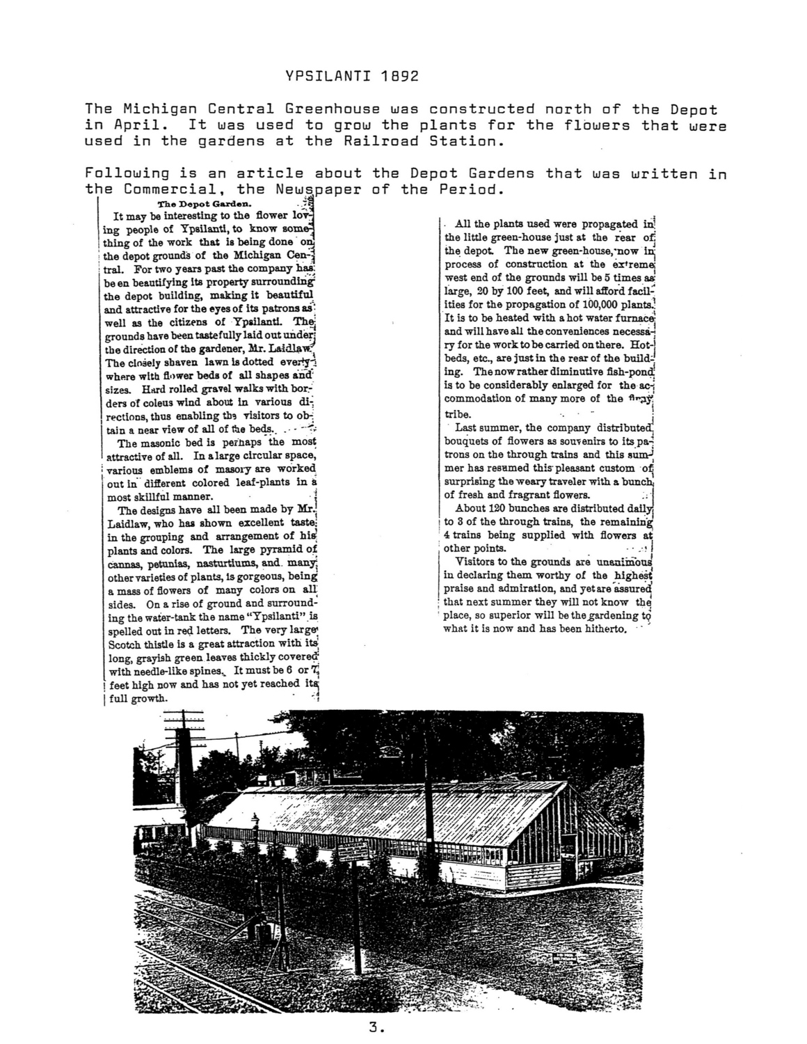
Building the County Parks
How a political gambit led the way
It is hard to imagine now just how rare parks were in Washtenaw County in 1972. Ann Arbor and other big towns had their own parks, and there were the Metroparks on the river and the state recreation areas at the northwest edge of the county. But the county’s only parks were a few rest areas run by the Washtenaw County Road Commission. Former road commission employee Carl Thayer remembers there wasn’t much to them—just “hand-mowed areas right beside the road with a picnic table and a green trash barrel.”
Things began to change in 1972, when Meri Lou Murray ran for county commissioner—by default. As Third Ward chair for the Ann Arbor Democratic Party, Murray was responsible for finding a candidate for her county board district. But since that district was then considered a Republican stronghold, no Democrat wanted to run. The party told Murray she would have to fill the slot herself.
Figuring they had nothing to lose, she and her campaign committee decided to think big—and came up with the idea of advocating for a county park system.
Murray won in an upset victory that fall and went on to shepherd into existence a county parks department that now has twenty-seven facilities on about 3,400 acres. The county system has thirty-three full-time employees, more than 300 seasonal jobs, and an annual budget that ranges from $6 million to $8 million depending on whether the system is buying land that year. And it’s long since expanded from rural parks to include active-recreation facilities and protected natural areas.
The Washtenaw County Parks and Recreation Commission held its first meeting in August 1973. Initially, all it oversaw was four roadside parks inherited from the road commission. But things began to pick up the following August, when WCPARC hired its first director, Bob Gamble.
Parks commissioner Nelson Meade recalls that the search had come down to two finalists, but one took a job in a bigger community, and the other hesitated to come to a county with no park millage to fund its system. Then, toward the end of the process, Gamble applied.
After reading his resume, which included being director of parks in Nassau County, Long Island, Meade wrote Gamble to say, “You’re out of our league. We can’t afford you.” But Gamble explained that his needs were modest and that he had lost the Nassau County job when the people who hired him were voted out of office. Although employed elsewhere, he was anxious to get back into park work. Meade recalls that at an interview in the county planning department’s conference room, “Bob lolled in his chair, but he charmed us. We hired him instantly.”
The commission still had virtually no budget, but one of the roadside parks, Park Lyndon, was surrounded by 205 undeveloped acres that the state had given to the county in 1960. Gamble got a federal grant to build a parking lot, a picnic pavilion, toilets, and a small cabin, and he recruited federally funded job training employees to lay out trails. Park Lyndon is now one of the jewels of the park system—“one of the premier nature preserves east of the Mississippi,” according to current county parks head Bob Tetens.
Murray recalls that the commissioners themselves helped set up fitness trails, using equipment made by the job trainees in a hangar at the city airport. At the County Service Center at Washtenaw and Hogback, formerly a Roman Catholic seminary, they commandeered the old gym for exercise classes, ignoring the noise from the sheriff’s shooting range in the basement.
Parks commissioner Bob Marans, a U-M professor of architecture and urban planning, arranged for students to survey county residents on their priorities for the new park system. Preserving open space came out on top, followed by a swimming beach and a park in the eastern part of the county. Gamble recommended creating parks at Independence Lake in Webster Township and on a property south of Ypsilanti with a small pond—today’s Rolling Hills County Park.
In August 1976 the county asked voters for a quarter-mill, ten-year park tax. Gamble stayed up all night after the election waiting for the votes to come in. When the final tally was announced, the proposal was 349 votes short of approval. “Bob was devastated,” recalls Nelson Meade. But the very next night the parks commissioners asked the board of commissioners to put the millage back on the fall ballot. They were worried that if they waited two years until the next countywide election, the land would be lost to private developers.
The night of the fall 1976 election, Gamble was so confident he went to bed at his normal time. He awoke the next morning to find that the millage had passed by 5,000 votes. Environmentally minded voters may have turned out in especially large numbers that year because the state’s returnable-bottle law proposal was on the ballot—but the county parks never again lost a millage campaign.
With a steady source of revenue, WCPARC won federal matching grants to buy and develop Independence Lake and Rolling Hills. Murray herself securied another key parcel when, after years of lobbying, she convinced her fellow county commissioners to donate the former county poor farm on Washtenaw to the park system. It’s now County Farm Park.
Bob Gamble retired in 1980. His successor, Roger Shedlock, oversaw the opening of Rolling Hills in 1983, and the historic Parker Mill on Geddes the following year.
The original ten-year millage was due to run out in 1986, but the parks commissioners decided to put the renewal on the ballot in 1984. They were pleasantly surprised when it easily passed on the first try.
In 1985, Shedlock was succeeded by Fred Barkley, a former county and regional planner. In July 1988, Barkley went to a convention in Portland, Oregon, to receive an award for Parker Mill’s trail system. “One day, while walking by the Portland City Hall,” Barkley recalls, “I saw kids playing in water shooting up in a spray.” He decided to add “interactive sprays” at both Independence Lake and Rolling Hills. At Rolling Hills, Barkley also replaced the original swimming pond with an elaborate water park complete with a water slide and a wave pool. According to Barkley, it was Michigan’s first public water park.
By then, most of the original millage was being spent to maintain the existing parks. The commissioners realized that if they wanted to continue to buy land, they would need another millage, and in 1988 voters approved a second quarter mill. Renewals of both the original and new millages easily passed in 1994 and 1998. The county uses one for operations and the other for park acquisitions and major improvements.
An indoor recreation center opened at County Farm Park in 1990. Built in the shape of a barn to honor the site’s history, it includes a swimming pool, a gym, exercise equipment, a walking area, and space for fitness classes. When Meri Lou Murray retired from the county commission in 1996, it was renamed in her honor. The Meri Lou Murray Recreation Center is now the most-used facility in the entire county park system.
Barkley’s last big projects were the golf course on Pierce Lake near Chelsea, more improvements at Rolling Hills and Independence Lake, and the purchase of Sharon Mills County Park near Manchester. Most of these were finished by his successor, Bob Tetens, who took over in 2001. Like Barkley, Tetens is a former planner who exudes enthusiasm for the parks. He seems to carry a mental map of the county in his head: whenever a potential park site is mentioned, he knows its physical properties and whether it is for sale or might be in the future.
Built in the 1830s on the Raisin River, Sharon Mills had been a Ford parts plant, a home, an antique store, and a winery before WCPARC bought it. The county restored the mill building and added handicapped-accessible restrooms, a pergola, terraces, and a pavilion. Plans call for adding walking and mountain bike trails on 119 recently purchased acres across the road.
In 2001 voters approved a new quarter-mill tax to preserve natural areas. At the time the county had just one nature preserve; now there are fourteen, all of them accessible to the public. “People can’t appreciate or understand nature unless they can experience it,” says Tetens.
The other big project since Tetens arrived has been the effort to complete a
border-to-border nonmotorized trail throughout the county. Also called “linear parks,” such trails open large stretches of land to the public. But they also require close collaboration with units of governments, individual landowners, and other park systems. “Some [obstacles] are difficult, some are expensive, but none are insurmountable,” says Tetens. He predicts that when it’s finished, the B2B trail will garner national recognition.
This year the county parks are thirty-five years old. With its second millage up for renewal, WCPARC has again developed a master plan describing what it will do with the money. For instance, since research shows a need for more sports facilities, the commissioners are working on an expansion plan for Rolling Hills that would include more space for disc golf and soccer and a “miracle field” with a rubberized surface that is safer for handicapped children and seniors. Similar improvements are being planned for the other parks. Also on the drawing boards is another indoor recreation center.
Tetens is very excited about the system’s future. “More than any other land use, parks have the ability to transcend time,” he says. “I am confident that the parks and preserves developed today will still be serving the Washtenaw County citizens a hundred years in the future. Parks are forever."
A Tale of Two Lakes
Side by side, separate resorts catered to blacks and whites
People once came from all over southeastern Michigan to play golf, dance, swim, and fish at two resorts on neighboring lakes north of Chelsea. But the guests rarely mingled, because one group was white and the other was black.
Both resorts were established in the 1920s—Inverness, on North Lake, by a white former Detroit business owner, and Wild Goose Lake, a short hop away, by three black families from Ann Arbor. The latter was born in controversy. When word first got out that some farmers were considering selling their land to blacks, neighbors circulated a petition urging them not to do so. When grocer Perry Noah refused to sign—he reportedly told the petitioners, “My father died in the Civil War to free these people”—his store was briefly boycotted.
The sellers, descendants of the area’s original settlers, refused to be intimidated. And that is how dual resorts, each with its own country club and a beach, grew up almost side by side.
The land around the two small lakes, about five miles north of Chelsea, was first permanently settled in 1833. Charles and John Glenn and their sister Jane Burk¬hart came from upstate New York with their spouses and children. Charles Glenn reportedly had decided to move west after his first wife and two young children were killed when flax she was spinning caught fire.
The siblings bought adjoining tracts of government land and built houses. Charles Glenn’s original house at 13175 North Territorial Road still stands. John Glenn had a fancier Italianate house down the road. The Burkharts settled just south of Wild Goose Lake.
Other settlers quickly followed, enough to justify a post office at North Lake in 1836. That year the Glenn family organized a Methodist church. Nineteen people gathered at John Glenn’s house for the first service, with Charles Glenn presiding as lay preacher. Ten years later the two brothers built a small church that also served as a school. In 1866 John Glenn deeded land for what is now the North Lake United Methodist Church. He also gave land for a cemetery on Riker Road.
The land around the lakes, hilly and full of glacial gravel, was best suited to fruit farming. Charles’s son Benjamin Glenn went into the nursery business with his cousins William and Robert, starting apple trees from seeds they procured at a cider mill. (At Wild Goose Lake today, aged apple, pear, and cherry trees are the remnants of a much larger orchard.)
The local Grange built a hall that served as the community’s social center. The North Lake Band, which played in neighboring towns, was based at the Grange Hall from about 1897 to 1906. In 1925 the North Lake church bought the building for $1 and moved it to church property to use as a Sunday school, dining room, and kitchen.
In 1920, Doug Fraser, president of American Brass and Iron Company in Detroit, retired and moved to North Lake. Fraser had ulcers, and his daughter Lauretta had contracted whooping cough, tonsillitis, and diphtheria; he hoped farming would be a healthier way of life for them both.
Fraser and his wife, Laura, bought John Glenn’s seven-bedroom Italianate farmhouse from John’s grandson Fred Glenn. The dining room was so large, Lauretta Fraser Sockow remembers, that the family preferred to eat meals in the sunroom next to the kitchen.
Sockow, now in her nineties, remembers how she loved the rural area as a child. She attended the one-room North Lake School at 1300 Hankerd, now a private home. Her family joined the North Lake church and sometimes hosted barn dances, playing music on their Victrola. Fraser grew apples, strawberries, raspberries, and currants and also raised pigs, but his pride and joy, according to Sockow, was his registered cattle.
Unfortunately, her father eventually developed an allergy to them. “His arms swelled up to the size of a football,” Sockow recalls, and he had to sell his animals and machinery and find another way of making a living.
His property reached all the way to North Lake, so in 1927 Fraser decided to start a resort. Invoking his Scottish heritage, he called it Inverness and gave its streets such names as Glencoe, Aberdeen, and Bramble Brae. He divided the land between his house and the lake into lots for cottages and set up the deeds so that all owners would have lake privileges. He put in tennis courts behind his house, and he built a nine-hole golf course, expanding into additional land he’d bought along North Territorial Road. He moved his family to Ann Arbor and turned the former Glenn home into the golf course’s clubhouse.
Fraser’s gamble paid off. In the 1920s, greater prosperity and rising car ownership created a new demand for resort communities, even in once-remote areas like North Lake. Ads for Inverness noted it was “only sixty miles from Detroit,” and Fraser encouraged potential buyers to drive out for the day to sample activities, such as pony rides for children and dances for adults (the clubhouse living room was big enough to accommodate two sets of square dances simultaneously). Sockow remembers that one neighbor might play the piano and another the violin.
Sylvia Gilbert, who today lives in the house built for the farm’s hired man, says the original clubhouse “was gorgeous. There was a beautiful powder room upstairs, wicker furniture. You could eat in the dining room or the sun porch.” Gilbert recalls dances where people would dress in kilts, and Halloween parties with elaborate decorations. Her house has since been moved from its original spot to 7095 Glencoe, around the corner.
Inverness attracted people of means from Detroit and Ann Arbor. Doctors, dentists, and businessmen built large cottages. Laurence Noah, Perry Noah’s son, earned money by doing chores for the summer people, such as delivering wood and taking away garbage. In the winter, Laurence and his father cut ice from North Lake and stored it to sell in the summer.
A mile away, at Wild Goose Country Club, the members enjoyed the same amenities as at Inverness—swimming, dancing, fishing, and golf. But for the people who frequented it, Wild Goose represented a much rarer opportunity.
“Blacks had no place to go,” explains Mercedes Baker Snyder. Her father, Charles Baker, along with Donald Grayer and Iva Pope, bought the land and organized the resort. Baker, co-owner of the Ann Arbor Foundry, was interested in the venture because “he loved golf, and blacks couldn’t play at public courses,” explains Mercedes’s husband, Charles Snyder.
The partners developed the club on the 250-acre farm of Sam and Fred Schultz, who were descendants of the original settlers, the Glenns. The petition drive that residents of North Lake started to keep out the black resort community didn’t deter the Schultzes. After the sale was completed on June 1, 1927, the Wild Goose Country Club was formed, with ninety-three lots for cottages and a stretch of communal lakeshore with a fishing dock. As at Inverness, the original farmhouse eventually was converted to a clubhouse. A nine-hole golf course began behind the clubhouse and went across Wild Goose Lake Road toward the lake. A dance hall was built on a hill.
Pawley and Carrie Grayer Sherman, Charles Baker’s father- and mother-in-law, became the first residents when they moved from Ann Arbor to the farmhouse. Mercedes Snyder, who came out for weekends to visit her grandparents, remembers it had three bedrooms downstairs, two big living rooms, and a big kitchen, but no plumbing. Her dad would play golf while the children romped around, walked in the woods, or swam in the lake.
The first two cottages, one built by the Shermans, the other by Donald Grayer, were log cabins made from Sears Roebuck kits. A couple more cabins were built before the Depression. The rest of the eighteen or so members merely owned unbuilt lots, which sold for $100. “At that time most Ann Arbor blacks worked in fraternities or cafeterias,” explains Charles Snyder. “Fifty cents an hour was considered a good wage, so they couldn’t afford to build.”
Most of the members were relatives or friends of the organizers. A much larger group, consisting of other friends and extended family members, came to visit and swim, dance, or golf. Visitors often traveled for hours to get there; in those days there weren’t many recreational facilities open to blacks.
Coleman Castro used to come in the 1930s to fish with Don Grayer Jr., his future brother-in-law. Ann Arbor resident Donald Calvert recalls coming out in the late 1940s or early 1950s to swim with friends at Wild Goose Lake. Back then, he says, the resorts favored by his white classmates, such as Zukey Lake or Groomes Beach at Whitmore Lake, did not allow blacks.
In its heyday, Wild Goose hosted big dances organized by Jim and Harriet Moore (a Sherman daughter), who moved into the clubhouse after the senior Shermans moved out. The public dances attracted blacks from all over southeastern Michigan. U-M dentistry graduate D. J. Grimes, who was one of the first black dentists in Detroit and a cousin of Jim Moore, told his Detroit friends about the dances and also put Moore in touch with good bands. Ann Arbor residents would go home after the dances, but the Detroit visitors often stayed, sleeping in rooms the Moores rented to them, either in the clubhouse or in another house they built across the road.
The lakeside resorts’ golden age was brief. Once the Depression hit, “people didn’t need cottages. People didn’t need to play golf,” says Sockow. Sales at Inverness dropped so precipitously that her father had to incorporate and bring in other investors to keep going. Although he ceded control of the development to a board of directors, he kept managing the country club until his death in 1952.
Cottage building completely stopped at Wild Goose Lake during the Depression. The dance hall was knocked over during a big storm in the 1930s and was never rebuilt. Russell Calvert, Donald’s brother, remembers that the golf course was still there in the late 1940s and 1950s but had become less popular because by then blacks could play on municipal courses. It eventually fell into disuse and is now overgrown.
North Lake residents and Wild Goose Country Club members apparently reached a state of grudging coexistence after the failure of the initial petition drive. Wild Goose people patronized North Lake businesses and report they were treated well. But the two groups did not socialize much.
After World War II, building at both lakes resumed. The prewar cottages were winterized and often enlarged, and the old prejudices began to ease. In the 1960s a Wild Goose resident, Bessie Russell, joined the North Lake church. “They were glad to have her,” recalls Mercedes Snyder. “They needed someone to play the organ.”
Today, both former resorts have turned into bedroom communities where working people and retirees live year round. At North Lake, the Inverness Country Club is going strong, with a waiting list to join. Buying a house in the original subdivision bestows automatic membership. The clubhouse has been replaced with a more modern building that looks like a ranch house.
The Wild Goose clubhouse was sold and is again a home. Much of the communal land, including the golf course, has also been sold and is divided into residential lots awaiting development.
The biggest change at Wild Goose Lake is that the population is now about 50 percent white. “As older blacks die, young blacks don’t want to live in the country,” explains Charles Snyder. But residents still often have family connections—including some that cross the old color line. Members of one of the new white families are the in-laws of Coleman Castro’s son, Tommie.
7-5-1 Doug Fraser boating on North Lake with daughter Lauren “Courtesy Sylvia Gilbert
7-5-2 Glenn House, later the country club “Courtesy Sylvia Gilbert”
7-5-3 Inverness clubhouse today “Courtesy Adrian Wylie”
7-5-4 Shirley, Sherman, Carl, and Mercedes Baker at Wild Goose Lake with their father, Charles, and grandfather Pawley Sherman. “Courtesy Mercedes Snyder”
7-5-5 Wild Goose sign “Courtesy Adrian Wylie”
7-5-6 Original plat for Inverness “Courtesy Sylvia Gilbert”
7-5-7 The first cottages at Wild Goose Country Club were log cabins built from Sears Roebuck kits “Courtesy Mercedes Synder”
7-5-8 Mercedes Baker Snyder and her husband, Charles, still enjoy the lake. “Courtesy Adrian Wylie”
Mullison's Stables
What went on at the fairgrounds the other fifty-one weeks of the year
For four days each fall from 1922 to 1942, Veterans Park was the site of the Washtenaw County Fair. The forty acres bounded by Jackson, Maple, and Dexter roads were filled with exhibits and events, including music, fireworks, and horse racing. The race horses were stabled near the track on the corner of Dexter and Maple, while show horses were on display in an exhibit barn near Jackson and Longman Lane.
The other fifty-one weeks of the year, the show barns turned back into Guy Mullison's riding stable. "Shorty" Mullison was only about 5 feet tall--so small, recalls retired U-M phys ed prof Marie Hartwig, that he looked incapable of governing a horse. "But the horse would do whatever he asked. You felt if he asked it to sit down and cross its legs, it would."
Born in 1876 in New York State, Mullison moved to Michigan with his family when he was five. As a young man, he ran the City Ice Company out of the barn behind his house at 326 East Ann (now part of the City Hall parking lot), using horse-drawn delivery wagons. He also had a part-time job taking care of the fire department horses, which were housed around the corner in the old fire station at Fifth Avenue and Huron.
Mullison started his stable in 1914 out of his home and for a while ran the ice company concurrently; he probably used some of the same horses. "It was popular," Hartwig recalls. "The horses were always out. I would get on a horse and go clopping through town until I came to the country. If a car came behind, I would get on the side. I remember being in some precarious positions until the car got by."
After the County Fair moved from what is now Burns Park to what is now Vets Park in 1922, Mullison moved the main part of his stable operation from his home out to the new fairgrounds. With the move, his customers no longer had to ride out to the country--they were already there. The Maple Village and Westgate shopping center sites were still farms, and even to the east there were open fields all the way down to the Eberwhite Woods.
When he moved, Mullison increased his stable from six horses to thirty. People who rode them still remember many of them by name: tall, plodding Ted, calm Barney, lively Jimmy McCracken, the beautiful Anne's Navy Girl, and the terrible Dickey Boy, who tried to knock his riders from the saddle.
Mullison also boarded a number of horses, including one belonging to the daughter of his vet, Dr. Lane, and Topper, which belonged to riding instructor Bertha Lyon. The boarders had their own box stalls, while most of Mullison's own horses were in standing stalls.
Mullison converted the box stall closest to the door into an office. A second fairgrounds barn served as an indoor riding area. Although respected as a good businessman (he counted Henry Ford and U-M president Alexander Ruthven among his friends), Mullison could not read or write--his wife, Gladys, did all the accounts.
Marty Ball, who as a teenager worked at the stable in exchange for a chance to ride the horses, remembers that people came every day, even in winter, to ride. If they rented the horse for an hour, they would usually ride in the area where Abbot School is now. If they had more time, they would go down to the Huron River, either straight north on Maple or out Miller to East Delhi--both Miller and Maple were still dirt roads with very little traffic.
Mullison also supplied horses for special events, including the National Guard's summer maneuvers in Grayling. Betty Smith remembers him painting one of his white horses red, white, and blue for a Fourth of July parade.
During the Depression, Mullison joined forces with horsewoman Bertha Lyon. Like Mullison, she had grown up on a farm and had always loved horses. (She told her daughter, Roberta Barstow, that as a child she used to tie horseshoes to her feet and pretend to be a horse.) Lyon arranged with the University of Michigan to offer riding in their physical education program. Hartwig remembers that the classes were very popular.
On Saturdays Lyon offered an all-day program for young people--mostly pre-teen girls at the horse-crazy stage, but some as young as five--whom she would pick up at their homes. Each would bring a bag lunch and dress appropriately in jodhpurs and boots. Dorothy Coffey still remembers Lyon's drill: "Knees in, heels down, back straight, hands up." In the summer, Lyon ran an informal riding camp at the DeForest farm, near Dixboro and Geddes roads (now Village Green apartments); she used six or eight of Mullison's horses, which she kept in a corral made of saplings. Students would ford Fleming Creek, ride through the woods and up a hill, and then canter across a field.
Lyon's alumnae rave about the experience even today. Coffey remembers how she waited all week for Saturday to come and how she would return home exhausted but happy. She says that Lyon "gave us a love of horses and fair play."
With the move, Mullison's customers no longer had to ride out to the country--they were already there. The Maple Village and Westgate shopping center sites were still farms, and even to the east there were open fields all the way down to the Eberwhite Woods.
Also fondly remembered are the excursions organized out of the stable: breakfast rides ending with coffee and doughnuts at the Mullison house on East Ann, supper rides ending at what is now Delhi Park to roast hot dogs, and moonlight rides--a favorite with the college kids. Lyon or an≠other stable employee would lead the expeditions, and Shorty and Gladys Mullison would meet them at the destination with food and supplies. Isabelle Reade, who began riding at age eight to strengthen her legs after recovering from polio, remembers a ride that ended up at a one-room school, where they played on the teeter-totter.
When it came time for the County Fair, Mullison moved his horses out of the barns, except for a few that might be needed by people entering riding competitions. Some would already be at Lyon's summer camp. Others were taken to a pasture on the Huron River near North Main Street.
Mullison died of a heart attack in 1941 at age sixty-four. The Jackson Road County Fairs lasted only a year longer. After the war the property was sold to the city for a park, and in 1955 the exhibit barns--by then considered a fire and health hazard--were torn down.
Bertha Lyon died in 1960. After she left Mullison's she set up her own stable on Joy Road, where she broke and trained many horses. She had a high reputation in the field, and her trainees won awards in shows all over the country, including Madison Square Garden. A horse named Cherokee Chieftain, who started out in Mullison's stable and was broken and trained by Lyon, went on to become famous as the Lone Ranger's horse, "Silver."
[Photo caption from original print edition]: (Left) "Shorty" Mullison on horseback at his Ann Street home. The riding stable grew out of an ice delivery business based in a barn behind the house. (Right) Mullison joined forces with riding instructor Bertha Lyon during the Depression. Lyon (top, far left) and students posed at Mullison's Stables at the county fairgrounds.
The Rise and Fall of Allen’s Creek
The stream that flows through Ann Arbor’s Old West Side hasn’t been seen above ground since 1926, but you can still see its influence everywhere.
Allen’s Creek, the site of the city’s first settlement, still runs through Ann Arbor’s west side. Named for Ann Arbor’s co-founder John Allen, it has a romantic sound to it, bringing to mind pictures of Potawatomi Indans following its course, settlers camping and picnicking on the banks, livestock drinking from it, and children playing in it. That idyllic picture has some truth in it, but Sam Schlecht, who knew it well in the years before it was put in a pipe below ground in 1926, says the creek was by then more like a “ditch in the road.” Historically, its value to Ann Arbor had more to do with urban development than natural beauty.
The main branch of Allen’s Creek runs northward roughly parallel to the Ann Arbor Railroad tracks, starting at Pioneer High and spilling into the Huron River just below Argo Dam. Three tributaries flow east into it from the Old West Side. Eber White starts on Lutz, crosses Seventh Street, and flows into the main stream at William; Murray-Washington rises at Virginia Park, crosses Slauson Middle School playground, and joins the creek near West Park; and West Park-Miller drains the ravine between MilIer and Huron.
Ann Arborites who were born after 1926 or who came to town after the creek was interred would probably not even know it exists except that it surfaces periodically as a political issue. In 1983, the voters approved a bond issue to repair it. And in recent years it has been part of an ongoing discussion about a possible Greenway that may include opening it up again.
Allen's Creek must have been named immediately after John Allen and Elisha Rumsey founded Ann Arbor in 1824. It is referred to by that name in all the early accounts and shows up on the map of "Ann-Arbour" that they registered in Detroit in May 1824.
Allen and Rumsey arrived here in February, looking for government land to buy as a town site. After returning to Detroit to pay for one square mile of property, they came back and set up camp on what is today the corner of First and Huron, with the creek right behind them as a water source. Rumsey and his wife, Mary Ann, later built a house on the site.

Allen’s Creek going by the Dean and Company warehouse near the Ann Arbor Railroad tracks between Liberty and Washington.
As Ann Arbor developed in the 1850s and 1860s, many businesses located along the creek. The creek apparently did not have a current strong enough to furnish real water power—the only industry that used it in that way was the Ward Flour Mill, at the mouth where the creek joined the Huron—but many businesses used its water for processing. Four tanneries on or near the creek used its water to soak cowhides and pelts of wild animals trapped in the surrounding forests. A foundry, Tripp, Ailes, and Price, on Huron Street where the Y is today, used the creek's water for its sand casting. And two breweries, the Western, later called the Michigan Union, on Fourth Street (today Math Reviews) and the City Brewery on First Street (today the Cavern Club), used the creek water to cool their beer.
In 1878, when the Ann Arbor Railroad reached town on its way between Toledo, Ohio, and Michigan's north, its developers chose the land beside Allen Creek to lay their track. Not only was it flat, but it was already the location of many of the industries they wanted to serve. Putting the tracks there guaranteed that the area would remain industrial even after water supply was no longer crucial.
As industry grew, so did the population. In 1846 William Maynard laid out the first section of the Old West Side, from First to Fourth streets. He added more streets in 1858 and 1861. But unlike today's subdivisions, with houses built one after another down each street, the area took shape slowly, with the higher land being built on first. The most desirable streets were Liberty, Huron, and Miller because they were high and dry. The three streets were laid out in a fan shape, rather than parallel, to avoid crossing the creek tributaries that ran between them.
Cross streets going down into the valleys between those main arteries weren't developed until years later. Murray and Mulholland streets, which cross the creek, were not laid out until 1911 and 1916. And some of the lowest parts of the creek bed were never built on at all--today they are West Park, Slauson playground, and the second Bach School playground.
A few west side homeowners took advantage of having the water nearby. David Allmendinger, owner of the downtown organ factory, built a house in 1890 at 719 West Washington, just in front of the creek. He dammed the creek to create a series of ponds, incorporating natural springs that were found on the property. He brought in soil to plant a rose garden and added a rustic bridge across the pond and a gazebo for family gatherings (he had thirteen children).
Allmendinger planted water lilies and stocked the pond with carp, one of which, according to family legend, answered to the name of Billy. But the carp were endangered when the city water pump station next door began drawing more water from the springs: the pond level fell so low that the family cat could catch fish by just reaching in.
Some westsiders used the creek more practically--to water their livestock. In the nineteenth and early twentieth centuries, the line between city and country wasn't as sharply drawn as it is now. Many people kept chickens, or even a horse or a cow, on their city lots. (There are still a number of barns around the Old West Side, used today as garages.) Sam Schlecht remembered his grandparents telling him of cows drinking from the creek near their Seventh Street house. Marty Schlenker's family told him that their livestock used to drink from the creek at First Street behind their Liberty Street hardware store.
Although the creek influenced the location of industry, houses, and the railroad, its importance had shrunk to almost nil by the early 1900s. Water was piped indoors after 1885, when the Ann Arbor Water Works Company was set up, so the creek was not necessary for industry, and homes and the railroad tracks had already been established. The only use for the creek was for recreation.
A stream running through a residential neighborhood can be a beauty spot and a play area, as the Allmendingers proved. But people around today who were children before the creek disappeared say that was the exception. Many interviewed said they didn't remember playing in the creek at all, while others remembered it as simply not important.
On hot days, Geraldine Seeback and her sister used to wade in the branch of the creek that ran by the east side of their parents' fluff rug factory on Huron, which replaced the foundry where the Y is today. Asked if her parents worried about her safety, Seeback laughs and says, "It wasn't dangerous." She remembers the water as about four feet wide but only ankle-deep.

Allen’s Creek flood in 1902 as it crosses Washington Street.
Karl Horning, who grew up on Third Street around the same time, has similar memories of the creek. He says, "It was nothing of significance; it didn't add anything to the city." He remembers that he and his friends could see the creek running under the Ann Arbor Railroad freight house on William and Ashley. The freight house was built right over the creek: evidently the creek was so small that builders just ignored it. Marty Schlenker remembered that the Feiner glass warehouse across the street from the freight house was also built over the creek.
Perhaps the person still around who is most familiar with the creek back then is Sam Schlecht, an inveterate explorer who lived in several different Old West Side houses as a boy and saw the creek from different vantage points. Between Seventh and Eighth streets, near Slauson Middle School (now Waterworks Park), the creek widened into a little pond. Schlecht and his friends made a burlap swing and attached it to a tree so they could swing out over the pond. If they fell in, they were in no danger of drowning--only of getting very dirty. Schlecht describes the pond as "slop water covered with algae," not deep enough for swimming.
Although the creek was low most of the time, it could overflow in the spring when the snow melted. Horning remembers that it would back up into gardens on First Street. That was a problem, since the water was polluted from outhouses and years of industrial use. In 1921, the city pumping station on Washington Street, which drew water from the springs that fed the Murray-Washington branch of Allen's Creek, was closed because of contamination from surface water.
In 1923, eighty-seven of the 100 property owners along the main branch of the creek petitioned city council to make it into a storm sewer. At a joint meeting that July, the city council and the Ann Arbor Township board agreed to the request. Alderman Herbert Slauson (for whom the school is named) said, "We do hereby determine that said proposed drain is necessary and conductive to the public health, convenience, and welfare."
It took three years to do the engineering and to enclose the main creek in underground cement pipes. The pipes taper from eleven feet in diameter at the mouth to four feet at the head waters near Pioneer High. In 1925, property owners along the West Park-Miller branch petitioned to have it put into a storm drain, and in 1927, residents along the Murray-Washington and Eber White branches followed. The tributary pipes range from four feet to about eighteen inches in diameter. In 1969 the creek and its tributaries were consolidated into the same drain district.
Sam Schlecht remembers when the creek was being put underground. The section near Keppler Court was on the path he followed to walk downtown, and he often stopped to watch the workmen. He remembers that although they had a primitive backhoe, a lot of their work was done by hand. When he got too close, the workmen would shoo him away. At the time, he remembers, Mulholland Street ended at the creek, with a cement wall to stop cars from going farther. After the creek was put into the pipe, Mulholland was extended across and turned north to end at Seventh Street. Later it was moved east to end at Washington.
The main section of the drain was finished in 1926, just after the city celebrated its hundredth anniversary. The Ann Arbor News wrote: "Planned as a part of the city's permanent sewerage to take care of the drainage from the creek's watershed for all time to come, it is probable that the concrete house for John Allen's creek once it is completed, will remain intact on the two hundredth anniversary of the founding of Ann Arbor."

Invisible for most of its course, Allen's Creek emerges to join the Huron below Argo Dam.
That was optimistic-—it was more like fifty years later that Allen's Creek again needed attention. The Allen Creek drain, as it is now known, flooded in 1947 and 1968. Putting a creek in a drain was no guarantee it would stay there-—the pipes, of course, hold a finite amount of water--and as Ann Arbor continued developing to the west, filling in more land with buildings, houses, and parking lots, the amount of runoff channeled into the drain kept increasing. By the mid-1970's, it became obvious that the Allen’s Creek drain needed a fresh appraisal.
A study commissioned by the city in the early 1980s offered a choice of several solutions. The most effective options--replacing the pipes with larger ones or building a second drain parallel to the first--were rejected as too expensive. Instead it was decided to repair the present system to make it as efficient as possible. Ann Arbor voters approved a $1.1 million bond issue, and in 1983 the city set to work repairing deteriorated culverts, relocating other utilities' pipes that crossed the drain, and resurfacing bottom areas that had eroded.
The bond money covered the most critical work. Since then, the Washtenaw County drain office and the city's engineering department have continued to work together on drain maintenance. The county is responsible for routine upkeep of the main line of the drain, while the city takes care of the tributaries going into neighborhoods. Major projects are financed using the county's full faith and credit and with the city’s storm water utility fees.
In 1993 the last two sections identified as needing work--an area near the Salvation Army headquarters on Arbana and another on Seventh Street near West Park--were completed. Both the city and county agree that Allen Creek drain is, at least for now, in good shape, even if undersized to serve its drainage area. Drain commissioner Janis Bobrin says there are "no visible areas of concern," but that the county "will continue to evaluate and maintain the drain."
Periodically people talk about opening up portions of the drain and returning it to a natural creek. Current discussion is focusing on the potential of creating a Greenway along the creek corridor. Whether Allen's Creek stays underground or not, its importance to the city has, if anything, continued to grow over the years. For instance, when Michigan Stadium was returned to natural turf in 1991, a tributary of the drain that ran right under the fifty-yard line was directed around the field and large pumps were installed to permanently lower the water table. The pumps allowed the U-M to lower the playing field itself by more than three feet--below the level at which it otherwise would have been covered with water. Without Allen’s Creek, Michigan Stadium would be a lake.
[Photo caption from book]: Map of Allen’s Creek. “Courtesy Washtenaw County Drain Commissioner”
Orange Risdon's 1825 Map
Michigan captured in its infancy The U-M’s Clements Library recently received a very rare 1825 map: one of the few remaining copies of Orange Risdon’s map of southeast Michigan. “It is the first map of Michigan that shows serious surveying and settlement,” explains Brian Leigh Dunnigan, the library’s curator of maps. Risdon, best known in this area as the founder of Saline, is also famous in Michigan history as the chief surveyor of the Detroit-Chicago Road, now US-12. Though Risdon’s surveys were done under government contract, the map was a private venture. Risdon drew it himself and paid to have it published, planning to sell copies to pioneers trying to pick out places to settle. Unfortunately for him, a former employee came out with a competing map and grabbed most of the market. But though it failed to make its creator rich, Risdon’s map today gives us a wealth of information about what our area looked like just one year after Ann Arbor was founded.

Map of the Surveyed Part of the Territory of Michigan, 1825.
Officially called “Map of the Surveyed Part of the Territory of Michigan,” it measures forty-three by twenty-nine inches. It shows the area from Toledo north to Saginaw Bay and includes Washtenaw County and a corner of Jackson County. Surveyors hired by the federal government started working in southeast Michigan when it was still a territory in 1818, since precise demarcation was a necessary prelude to selling the land. They divided the state into counties, the counties into six-mile-square townships, and the townships into square-mile (640-acre) sections. The grid allowed buyers, when they went to the land office to buy land, to clearly identify their purchase. Although a few intrepid settlers came earlier, serious settlement in Washtenaw County did not begin until the 1820s. Ypsilanti was founded in 1823 or 1825, depending on how the city is defined. Ann Arbor, Dexter, and Dixboro were all founded in 1824. The Risdon map, although strictly a factual document, reveals two historic transitions, one long past at the time it was published, the other still to come. The long, narrow lots Risdon mapped along the rivers in Detroit and Monroe were legacies of the French who were the state’s first white inhabitants. “They all had access to the water,” explains Dunnigan. Risdon’s map also shows Toledo, then called Port Lawrence, as part of Michigan. Though it was indeed within Michigan Territory as defined by Congress, Ohio made a strong claim, and the issue was further muddied by years of contested surveys. The conflict briefly turned violent in the “Toledo War” of 1835 and would not finally be settled until 1836, when Michigan accepted a federal ultimatum to cede the city to Ohio in exchange for the Upper Peninsula. The handful of roads shown all lead from Detroit to surrounding towns: one to Saginaw (now Woodward Avenue) and one to Port Huron (now Gratiot Avenue), as well as the road to present-day Chicago. Tepees mark the location of Indian settlements, but there are none in Washtenaw County (the closest ones are in Macon and Wyandotte). Near Detroit, Hamtramck has already been established; Dearborn also is there, but not under that name—Risdon calls it “Bucklin.” The Washtenaw County shown on the map is larger than it is today, because it includes two townships that are now part of Jackson County. Ann Arbor is spelled “Ann Arbour,” which is how founders John Allen and Elisha Rumsey spelled it when they platted their 640-acre parcel the year before. Dixboro is also spelled the old-fashioned way, “Dixborough.” All of the county’s townships, with the exception of present-day Lyndon Township, are sectioned off, but none is yet named. The map contains practical information for would-be settlers, such as the location of inns and where to register land purchases. In Washtenaw County, the only inn outside of the towns was labeled Sutton, in today’s Northfield Township. Settlers had to go to Detroit to buy property in Washtenaw County, except for those acquiring land in the southern tier of townships—today’s Manchester, Bridgewater, Saline, York, and Augusta—who were directed to Monroe. Only five settlements are shown in Washtenaw County: besides Ann Arbour, Dixborough, and Dexter there are Ypsilanti and Woodruff’s Grove. Showing the last two as separate places adds fuel to a continuing debate between Ann Arbor and Ypsilanti over which was settled first. It is clear that Ann Arbor was founded in 1824 and Ypsilanti in 1825—but Woodruff’s Grove was founded in 1823, and it was later absorbed by Ypsilanti. Saline is not shown on the map; by the time Risdon drew it he had bought the land for his own settlement, but he would not get around to laying out the town until 1832. The only marking is a salt spring nearby. Orange Risdon was particularly well qualified to make this map, being both a trained surveyor and an early Michigan settler. Risdon was born in 1786 in Vermont and moved with his family to Saratoga County, in eastern New York, when he was three. He attended local schools until age thirteen. Afterward, according to the 1881 Chapman History of Washtenaw County, Michigan, “he was dependent on his own efforts.” Risdon studied surveying under a Mr. Rice of Ballston Spa, New York. In 1807, when he was twenty-one, Risdon got a job assisting the noted surveyor Elisha Johnson, who had a contract to survey 100,000 acres in the new counties of Allegany and Genesee. “His duty was to carry the chain, for which he was to receive $16 per month, but scarcely a week had passed when his skill in surveying was discovered, and with the consent of the land agent, the work was divided, and his wages increased to about five times the amount of the first stipulation,” says the county history. Two years later Risdon was hired to assist in laying out the infant cities of Lockport, Brockport, and Buffalo. During the War of 1812 he worked for the federal government as an assistant surveyor. After the war he met Sally Newland, and the couple married in 1816. Risdon bought land with his earnings, eventually owning 1,000 acres on New York’s Genesee River. Risdon resolved to move to Michigan Territory after suffering losses in the 1817 commercial crisis, but he did not arrive in Michigan until 1823, when he spent a month traveling on foot through Washtenaw and other nearby counties. He returned the next year, this time spending four months on a 2,000-mile exploring trip on horseback with Samuel Dexter. After their trip Dexter bought land on Mill Creek, just off the Huron River, and began the work of establishing the village that bears his name. Risdon bought 160 acres on the Saline River and the Indian trail that would soon become the Detroit-Chicago Road, land that would later be the nucleus of the city of Saline. How Risdon and Dexter met is lost to history. They could have known each other from New York, since Risdon’s parents still lived in Sarasota County and Dexter resided in Athens, two counties south, or they may have met while traveling. Their backgrounds were very different: Risdon was six years older and had been supporting himself since he was thirteen, while Dexter had both a bachelor’s and a master’s degree from Harvard. (Dexter’s father had served in the cabinets of both Adams and Jefferson.) But both have gone down in history as town founders who went well beyond land speculation and worked to improve their towns. They both offered free land to any church wishing to get established, and they were both abolitionists who were rumored to be part of the Underground Railroad. It is easy to imagine that they discussed these issues during their long hours of travel together. Risdon’s reputation as a surveyor followed him to Michigan, and in the same year he bought his land he was hired to direct a survey for a road connecting Detroit and Pontiac. In fall 1824, when he must have been almost done surveying for the season, he began work on his map. From his two exploring trips, plus his surveying work, Risdon would have known much of the area firsthand, and for the rest he could rely on work done on earlier surveys. Risdon advertised in the Detroit Gazette on October 1, 1824, seeking advance subscriptions to pay for the cost of producing the map. He promised that “the work will be put into the hands of the engraver as soon as a sufficient number of subscribers is obtained to warrant the expense of publication.” The ad pitched the map as useful to emigrants and explorers: “The first thing necessary to an immigrant is a general knowledge of the surveyed portion of the territory, of the course of its streams and the relative situation of its different parts. The publisher, having spent some time in exploring that junction of the territory embraced in his map, will be enabled to locate the most important Indian paths, which as they were made by those who were acquainted with every part of the country will be an important guide in the future location of our roads.” Risdon promised that the map also would include Indian reservations and villages and would “embrace the lines of counties, townships, and sections, regularly numbered according to the surveys.” Although the mapping of Michigan had been going on for six years, settlement had been slow, both because Michigan was off the beaten path (easterners going west overland were more likely to pass through Ohio and Indiana) and because the territory was rumored to be all swamp. The first problem would be solved a year later when the Erie Canal opened, making it easy for easterners to reach Buffalo, where they could board a Lake Erie steamboat for Detroit. Risdon addressed the swamp story head-on in his ad: “The country which was formerly believed to be uninhabitable excepting on the river and lake shores, abounds in lands of the most fertile and healthy description.” Even the climate, he claimed, “is particularly adapted to our eastern constitution.” The maps were to be “engraved in an elegant style and published on Super Royal paper.” Risdon offered his map in three formats: in two sheets that could be stored flat in a drawer, for $2.50; cut into twenty-four sections and pasted on linen--so that the map could be folded without losing detail--and supplied with a leather carrying case, for $3; or varnished on rollers, perfect for land agents and lawyers who would be consulting it in their offices, also for $3. The Clements Library’s copy is of the last type. The next year, 1825, Risdon started the job for which he is most famous: chief surveyor for the great military road from Detroit to Chicago, today known as Michigan Avenue or US-12. Work on the survey no doubt showed him features to include on the map but left him little time to work on it. He hired a helper named John Farmer, finished the map, and sent it to Rawdon, Clark, and Company in Albany, New York. On November 13 he paid them $400 for engraving the two copper plates. Five weeks later he paid to have 472 copies printed. After printing, each copy was hand painted. By the time they were ready to deliver, however, winter had shut down shipping on Lake Erie. Risdon’s subscribers had to wait until May 1826 for an announcement in the Detroit Gazette that their copies were ready. That delay proved fatal to the map’s commercial prospects. Later in the summer of 1826, Farmer published his own rival map. It was basically the same as Risdon’s but with added details that had been learned in the interim. Farmer’s map, being more up to date, overshadowed his employer’s. “It was bad luck that Orange didn’t get the map in time to get it promptly to the subscribers,” says Brian Dunnigan. By examining both maps, Dunnigan can tell that Farmer had probably done most of the hand coloring on Risdon’s map. “John Farmer dominates after this--he becomes ‘the’ Michigan map-maker,” says Dunnigan. “He is probably the best-known Michigan mapmaker of the nineteenth century.” Risdon moved on from the failure of his map, earning a good living as a surveyor. He surveyed at least seventy-five townships and the city of Saginaw, and he reexamined or resurveyed forty-five more townships. He continued working for the government until 1856, when he was seventy. By then his own village was well established. In 1829 Risdon had returned to his property south of Ann Arbor and built a twelve-room house on a hill overlooking his Detroit-Chicago Road. He brought his family out from New York and began building up his new town. His house was used as Saline’s first inn, post office, general store, and polling place. Risdon himself served as postmaster and magistrate, officiating at the first marriage in the township. After Michigan became a state in 1837, he was elected to the Michigan House of Representatives. Risdon’s “advice was often sought in the selection of lands,” the county history records. “Very many miles were traveled by him to point out desirable locations, yet [he was] ever unwilling to receive a reward.” Although there is no evidence that he made any other maps, his contemporaries knew of his pioneering effort. L. D. Norris, in an address to the Washtenaw County Historical Society in 1874, said, “The first general map of the surveyed part of this territory of which I have any knowledge was published in 1825 by Orange Risdon, then and now a pioneer of Washtenaw.” Risdon died in 1876 at age ninety, a well-regarded member of the community. “He was genial in his disposition, unselfish, benevolent, and liberal almost to a fault,” said the county history. At his funeral, “great numbers of people from neighboring towns and cities were in attendance.” His home passed to his daughter after his death. In 1948 the house was moved to Henry Street to make room for expansion of Oakwood Cemetery. Still standing, it has been divided into apartments. The Clements copy of Risdon’s map was a gift from the Michigan Map Society, purchased to honor Frank Kerwin, a founding member of the society who recently died. The Michigan Map Society meets at the Clements and works closely with the library, so members knew that although the Clements had a large collection of Great Lakes maps, it was missing this very important one. Since Kerwin, a Grosse Pointe resident and sailor, was himself a collector of Great Lakes maps, the Risdon map, a copy of which had gone on the market, seemed a logical choice. Of the 472 copies originally printed, only thirteen are known to have survived. Kerwin lived long enough to learn of the purchase but died before the formal presentation last May. The map society has about seventy members; most are from the Ann Arbor and Detroit areas, but some come from more distant places, such as Lansing and Grand Rapids. Although mostly amateurs, they are a very knowledgeable group; many are serious map collectors. Several of them volunteer their expertise to help the Clements staff. They meet four times a year to hear map-related lectures; including a talk by Dunnigan on his book, Frontier Metropolis: Picturing Early Detroit, 1701–1838, before it was published. Since the Clements is a research library, people cannot just come in and casually look at Risdon’s map. “Serious researchers may study the map once they have completed our reader registration process, which is relatively simple,” explains Dunnigan. The map itself will also be exhibited from time to time, but at the moment, no public exhibition is scheduled.

Weinberg's Peony Garden
On Ann Arbor's west side, there once flourished an amazing garden which, from 1920 until 1952, was one of the city's notable beauty spots. Weinberg's peony garden, as it was known, also included poppies, irises, and lilacs. Its landscaping included many favorite picturesque features of the 1920s: a sunken garden, a rock garden, and a fish pond with water lilies. Owner Carl Weinberg had started the garden behind his house at 514 South Seventh and gradually extended it until it covered an area bounded by Jefferson Court to the north and Lutz to the south, stretching from Seventh all the way to Eberwhite.
Peonies were Carl Weinberg's favorite flower. He grew many species, including some exotic specimens like a Japanese tree peony and an Alice Harding peony from Nice, for which he is said to have paid $250. Weinberg himself developed some new peony strains, which he named for friends and relatives. A double white peony is named after his wife, Elenora; another is named after his nephew, Bobby Faust, and a third after Andrew Muehlig, his friend. A dark red poppy he named after himself.
The garden's main commercial activity was selling cut flowers to florists like Nielsen's. Roots for planting stock were also sold. But the garden was much more than a business. It was an Ann Arbor landmark and a passion for its owner. People often came to the garden just to enjoy walking through it, especially on weekends. Friends recall Weinberg giving away more flowers than he actually sold. Flowers often appeared at Bertha Muehlig's store and at her brother's funeral parlor. Weddings were sometimes held in the gardens, and neighborhood teenagers earned pocket money by weeding and spraying there.
Carl Weinberg could afford to be generous. His main source of income was a successful contracting business. He grew up in the house at 514 South Seventh and at first worked as a foreman for his older brother, Fred, a contractor and also proprietor of Weinberg's skating rink (now the U-M Coliseum) and swimming pool. When Fred died in 1917, Carl, then thirty-seven, went into the construction business for himself, joining with mason Walter Kurtz. Their firm was on Jefferson Court, behind Weinberg's house. (The old block buildings now house Butcher and Willits Construction.) The horses that pulled the equipment were stabled in the big stone barn behind Kurtz's house at 520 First Street. Later, Kurtz moved to 500 South Seventh to be nearer his work, and Weinberg built himself the unusual brick house at 2 Jefferson Court.
Weinberg and Kurtz sold building supplies and built homes and commercial buildings. When winter put an end to the construction season, the staff kept busy making stone decorations like bird baths, planter boxes, and ornamenta1 benches. The project they were proudest of was the home of optician Dean Meyer at 1917 Washtenaw, today converted into part of the Unitarian Church. For years, a picture of the Meyer house dressed up Weinberg and Kurtz's checks.
In 1940, Weinberg sold his share of the construction business and devoted the rest of his life to gardening. Today a small remnant of the original garden survives next to the house at 1114 Lutz. It is a sunken area, with peonies and a number of stone ornaments. Weinberg's nephew, Rudy Golz, who built the house in 1942, still lives there and cares for the remaining part of the once vast garden.
In June, some of Weinberg's peonies can be seen in bloom in the Arboretum, in the part near Mary Markley Dormitory. Weinberg traded and consulted with the university's horticulture experts, and they have preserved this large selection.
[Photo caption from original print edition]: In its heydey, the garden was extensive.
[Photo caption from original print edition]: Elenora and Carl Weinberg with spaniel puppies.
[Photo caption from original print edition]: Picturesque concrete ornaments like these rustic seats were made by Weinberg and Kurtz's building crews in the off-season. This shady nook in the side yard of 1114 Lutz is basically all that remains of the garden.
[Photo caption from original print edition]: View of part of the rock garden. In the rear, the concrete block headquarters of Weinberg and Kurtz contractors on Jefferson Court (now occupied by Butcher and Willits Construction).